Gone are the days when tracking wildlife meant spending hours on your hands and knees, deciphering faint footprints in the mud. While those classic skills are still invaluable and deeply rewarding, the digital age has given us a powerful new tool: the Global Positioning System (GPS). Whether you’re a curious hiker, a dedicated hunter, or a citizen scientist, learning how to use GPS to track wildlife opens up a fascinating new window into the natural world.
The global Wildlife Tracking System Market size was approximately USD 25.31 billion in 2024 and is expected to reach USD 60.46 billion by 2032, growing at a CAGR of about 11.5%, demonstrating the rapidly expanding role of technology in wildlife observation and conservation. This isn’t about spying; it’s about understanding. It’s about uncovering the hidden highways animals use, discovering their secret bedding areas, and gaining a profound appreciation for their movement patterns. Here’s how you can start.
1. The Gear: What You’ll Need on the Digital Trail
You essentially have two paths: using a dedicated handheld GPS device or your smartphone. With the recent miniaturization of GPS technology, scientists can attach tracking devices that weigh less than half an ounce to smaller animals, and this same advancement has made consumer GPS devices more accurate and accessible than ever before.
Handheld GPS Receivers
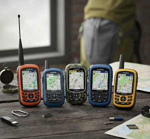
Garmin GPSMAP Series and Similar Devices: These are the workhorses of the outdoor world. Modern handheld GPS units offer remarkable precision, often accurate within 3-5 meters under optimal conditions. They are built tough, waterproof (typically IPX7 rated), have extended battery life (up to 20+ hours depending on usage), and work in areas with no cell service. Their anti-glare screens remain visible in direct sunlight, and they are designed specifically for precise navigation and tracking.
Key features to look for in 2024-2025 models include:
- Multi-GNSS support (GPS, GLONASS, Galileo) for enhanced accuracy
- Preloaded topographic maps with annual updates
- Wireless connectivity for data sharing
- Expanded memory for custom maps and waypoints
- Enhanced compass and altimeter functions
Smartphone GPS Solutions
Almost everyone has one, and modern smartphones have become surprisingly capable tracking tools. With over 9,000 satellites orbiting Earth in 2025, smartphone GPS accuracy has improved dramatically. Popular apps include:
OnX Hunt: Trusted by millions of hunters, onX Hunt offers private and public land boundaries, 3D satellite and topographic basemaps, offline maps, and hunt-specific layers such as historic wildfires, possible access, and game management units. The app has evolved to include advanced features like wind direction overlays and property boundary alerts.
Gaia GPS: Excellent for backcountry navigation with detailed topographic maps and robust offline capabilities.
HuntStand: Features GPS maps, tools, and has maintained user loyalty for nearly a decade, with some users reporting nine years of continuous use.
HuntWise: Helps hunters utilize the right information at the right time to help improve their odds of success in the woods, combining GPS functionality with weather data and hunting predictions.
The downsides of smartphones remain: battery life drains quickly in GPS mode, screens can be difficult to see in direct sunlight, and they are not always rugged or waterproof. However, modern flagship smartphones often include military-grade durability ratings and improved battery management.
Pro Tip: Always put your phone in Airplane Mode and only enable GPS. This saves massive battery life while still allowing the GPS chip to function. Consider investing in a portable battery bank rated for outdoor use.
Whichever you choose, the core function you’ll use is marking Waypoints. A waypoint is a digital “pin” you drop on your map to record a specific location’s coordinates with unprecedented accuracy.
2. The Art of the Find: What to Look For and Mark
GPS doesn’t replace observation; it enhances it. GPS tracking systems can record huge amounts of highly accurate animal locations with minimal work by operators, thus allowing reduced sampling intervals, and increased accuracy and performance when compared with very high-frequency (VHF) radio-tracking systems. Your job is to find the signs first. When you discover something significant, that’s when you mark a waypoint.
Tracks and Trails
Find a clear set of tracks? Mark it with detailed notes about track size, gait pattern, and direction of travel. Notice a well-worn game trail cutting through the brush? Mark the start and end points, noting the trail width and apparent frequency of use. Over time, you can connect these points to see the animal’s preferred routes and seasonal variations in movement patterns.
Modern GPS units allow you to add detailed annotations to each waypoint, including:
- Time and date of observation
- Weather conditions
- Track measurements
- Photographic evidence (if your device supports it)
- Behavioral observations
Scat (Droppings)
This is a goldmine of information that has become even more valuable with GPS precision. Not only does it tell you an animal was there, but its contents can reveal dietary information, health status, and seasonal feeding patterns. Mark these waypoints and consider renaming them descriptively (e.g., “White-tailed Deer Scat – Acorn Rich” instead of “Waypoint 042”).
Advanced practitioners often photograph scat alongside GPS coordinates, creating a comprehensive database that can reveal:
- Seasonal diet changes
- Territory boundaries
- Population health indicators
- Stress levels during different seasons
Bedding and Resting Areas
Flattened grass in a sheltered spot, a deer bed, or a hollowed-out area under a log represent critical habitat information. These locations are key to understanding where animals feel safe and secure. GPS coordinates of bedding areas can reveal:
- Preferred elevation ranges
- Proximity to water sources
- Relationship to prevailing wind patterns
- Seasonal shifts in bedding preferences
Rubs and Scrapes
For deer hunters and wildlife observers, this data is invaluable. A buck makes rubs on trees and scrapes on the ground to mark its territory and communicate with other deer. Marking these during pre-season scouting can help you pattern a specific animal and understand territorial boundaries.
Modern GPS tracking allows you to categorize different types of sign:
- Fresh rubs vs. old rubs
- Scrape size and activity level
- Tree species preferences for rubbing
- Seasonal timing of marking behavior
Food and Water Sources
A grove of oak trees producing acorns, a berry patch in peak season, a creek, or a pond represent critical resources in any animal’s habitat. Animals repeatedly visit these areas, and GPS coordinates help you build a comprehensive map of resource availability.
This information becomes particularly valuable when combined with seasonal data:
- Spring green-up patterns
- Summer drought impacts on water sources
- Fall mast production variations
- Winter food scarcity adaptations
Kill Sites or Remains
If you discover bones, feathers, or the site of a predator’s meal, mark it carefully. This can be vital data for understanding predator-prey relationships and ecosystem health. GPS coordinates of kill sites can reveal:
- Predator hunting patterns
- Prey species preferences
- Seasonal predation trends
- Territory overlap between species
3. From Points to Patterns: Making Your Data Talk
This is where the magic happens. Recent advances in wildlife tracking techniques have enabled large-scale data collection on the detailed movements of many animal species, and the same principles apply to your personal observations. Tracking single waypoints is interesting, but the real power lies in the patterns you uncover through data analysis.
The Power of the Track Back
Most GPS devices and apps have a “Track” or “TracBack” feature that creates a breadcrumb trail of your entire journey. When you overlay your marked waypoints (scrapes, beds, feeding signs) onto your own path, you can see exactly where you found evidence in relation to the landscape features.
This feature has evolved to include:
- Elevation profiles of your route
- Time stamps for each segment
- Speed and direction data
- Weather correlation capabilities
Advanced Map Overlays and Analysis
Upload your data to computer-based platforms for sophisticated analysis. Apps like OnX Hunt and Gaia GPS offer powerful desktop interfaces where you can visualize all your waypoints on detailed satellite imagery, topographic maps, or specialized hunting maps.
Modern analysis might reveal that:
- All deer scrapes occur on south-facing ridges between 1,200-1,400 feet elevation
- Game trails consistently follow specific elevation contours
- Feeding sign concentrates within 200 yards of water sources
- Bedding areas maintain consistent distances from human activity
Connect the Dots: Predictive Modeling
By analyzing your collected data over multiple trips and seasons, you can start to predict animal movement with remarkable accuracy. You’ll learn where they eat, where they sleep, and the paths they take between these critical areas.
This creates a predictive model that proves invaluable for:
- Wildlife photography positioning
- Hunting stand placement
- Scientific observation planning
- Conservation habitat assessment
Advanced practitioners often use GIS (Geographic Information System) software to create heat maps, movement corridors, and probability zones based on their collected data.
Seasonal Pattern Recognition
GPS data becomes exponentially more valuable when collected across multiple seasons. Patterns emerge that would be impossible to detect through casual observation:
Spring Patterns: Emergence from winter yards, movement to new food sources, territorial establishment Summer Patterns: Daily movement between feeding and resting areas, water dependency increases Fall Patterns: Pre-breeding behavior, territory expansion, food cache development Winter Patterns: Concentration in thermal cover, reduced movement ranges, group behavior changes
4. Ethical Tracking: Be a Ghost in the Woods
With this technology comes great responsibility. GPS tracking technology has significantly impacted wildlife conservation efforts, with GPS collars on elephants resulting in a 50% decrease in poaching incidents in some protected areas of Africa. Our goal as recreational trackers is to observe without disturbing, contributing positively to wildlife understanding and conservation.
Minimize Your Impact
Practice Leave No Trace principles religiously. The goal is for the animal to never know you were there. This means:
- Avoiding direct approaches to bedding areas
- Minimizing scent trails in sensitive areas
- Using existing trails when possible
- Avoiding repeated visits to the same locations
Respect Private Land and Legal Boundaries
Always know whose land you are on and obtain permission for private property access. Modern GPS hunting apps excel at showing property lines with surveyor-level accuracy, helping you stay legal and ethical.
Key considerations include:
- Understanding hunting seasons and regulations
- Respecting posted boundaries
- Obtaining proper licenses and permits
- Following local wildlife viewing guidelines
Avoid Stressful Times
Be especially cautious during critical periods when animals are most vulnerable:
- Winter: When animals are conserving energy and may be near starvation
- Spring: During fawning, nesting, and breeding seasons
- Summer: During extreme heat when animals seek limited shade and water
- Fall: During breeding seasons when animals are already stressed
Legal and Ethical Guidelines
It’s illegal to harass wildlife in most jurisdictions. Using GPS to repeatedly seek out and disturb animals is unethical and often illegal. Understanding the difference between observation and harassment is crucial:
Acceptable: Passive observation from appropriate distances, marking sign and evidence, tracking historical movement patterns Unacceptable: Pursuing animals, approaching nests or young, using technology to corner or trap wildlife
5. Beyond the Hobby: GPS in Professional Conservation
The same principles you use for recreational tracking are employed by professional biologists on a much larger scale. By the end of 2024, over 150 rhinos are expected to be equipped with trackable horn pods, with biologists using the data to monitor and study different rhino populations for conservation purposes.
Professional applications include:
Population Monitoring
GPS collar data helps scientists:
- Monitor endangered species populations: Track breeding success, survival rates, and population trends
- Understand migration corridors: Protect critical pathways from development and human interference
- Study climate change impacts: Document shifts in animal movement patterns as habitats change
- Manage game species: Maintain healthy ecosystems through informed hunting quotas and habitat management
Advanced Research Applications
The data collected from GPS and high-resolution satellite imagery allow researchers to identify and monitor wildlife movement, patterns, species numbers, behaviors, and to prevent poaching. Modern research applications include:
- Predator-prey relationship studies: Understanding ecosystem balance and food web dynamics
- Disease transmission modeling: Tracking how diseases spread through wildlife populations
- Human-wildlife conflict mitigation: Identifying areas where wildlife and human activities intersect problematically
- Habitat corridor design: Creating wildlife passages that facilitate safe animal movement
Citizen Science Opportunities
Your GPS tracking data can contribute to larger scientific efforts:
- iNaturalist: Upload observations with GPS coordinates to contribute to biodiversity databases
- eBird: Submit bird sightings with precise location data
- Wildlife tracking projects: Many universities and wildlife agencies welcome volunteer data collection
- Conservation organizations: Groups like the National Wildlife Federation often seek volunteer trackers
6. Technology Integration and Future Trends
The field of wildlife tracking continues to evolve rapidly. Wildlife tracking technology trends of 2025 focus on engaging movement data visualization, making data more accessible and actionable for both professionals and enthusiasts.
Emerging Technologies
- Improved satellite coverage: Enhanced accuracy and reduced signal acquisition time
- AI-powered pattern recognition: Software that can automatically identify animal sign in photographs
- Integration with weather data: Real-time correlation between animal activity and environmental conditions
- Social sharing platforms: Secure ways to share data while protecting sensitive wildlife locations
Equipment Recommendations by Budget
Budget Option ($0-100):
- Smartphone with offline maps app
- Portable battery bank
- Waterproof case
- Basic notebook for manual observations
Mid-Range Option ($100-500):
- Entry-level handheld GPS (Garmin eTrex or similar)
- Premium GPS app subscription
- Weather-resistant gear
- Digital camera for documentation
Professional Option ($500+):
- High-end GPS with satellite communication
- Professional mapping software
- Trail cameras for automated monitoring
- Advanced weather monitoring equipment
Conclusion: Mapping the Invisible World
By learning to track with GPS, you’re not just becoming a better outdoorsperson; you’re learning the language of the landscape. You’re translating the subtle signs you find into a digital story, revealing the secret lives of the animals that walk the same ground we do.
The technology available today provides unprecedented opportunities to understand wildlife behavior, contribute to conservation efforts, and develop a deeper connection with the natural world. Whether you’re marking your first deer track or contributing data to a professional research project, GPS wildlife tracking opens doors to discovery that previous generations of naturalists could only dream of.
As you charge your devices and head into the woods, remember that you’re participating in a revolution in wildlife understanding. Every waypoint you mark, every pattern you discover, and every insight you gain contributes to our collective knowledge of the incredible animals that share our world. Start mapping the invisible world all around you, and prepare to be amazed by what you discover.
*) If you enjoyed this article, here are some related posts you might find interesting.