There’s a special kind of magic to winter hiking. The world is hushed under a blanket of snow, the air is crisp, and the views are unobstructed and starkly beautiful. But let’s be real: winter is also a master of disguise. A familiar summer trail becomes an alien landscape. That well-marked path? Buried under several feet of powder. Those obvious landmarks? Transformed into unrecognizable ice sculptures or completely obscured by heavy snowfall and fog.
Getting lost isn’t just an inconvenience in the cold; it’s a serious danger. Hypothermia can set in within minutes when temperatures plummet, and even experienced hikers can find themselves disoriented when whiteout conditions erase all visual references. Search and rescue operations become exponentially more complex in winter conditions, with response times often delayed by hours or even days depending on weather severity.
That’s why your gear list needs a serious upgrade, starting with your navigation. Your phone? It’s a fantastic tool, until the battery gives up the ghost in the freezing temps. You need a dedicated, rugged, and reliable GPS device that laughs in the face of a blizzard. We’ve braved the digital landscape to find the best GPS units that will keep you on track when the mercury plummets.
Why Your Phone Isn’t Enough for a Winter Wonderland
Before we dive in, let’s settle this. You might be thinking, “But my phone has a great GPS!” And you’re right, it does—for a while. Here’s the cold, hard truth:
Battery Vampirism: The Cold Hard Facts
Cold kills lithium-ion batteries with shocking speed, causing them to lose up to 20% of their capacity when temperatures drop below freezing. Your phone that was at 80% at the trailhead can be dead in an hour if it’s exposed to the cold. This isn’t just inconvenient—it’s potentially life-threatening when you’re miles from the nearest road.
Lithium-ion batteries have an optimal operating range between 20°C to 25°C (68°F to 77°F), and when temperatures drop below freezing (0°C or 32°F), the battery’s performance starts to degrade. The chemical reactions that power your device literally slow down in the cold, making it harder for the battery to deliver power efficiently. Most smartphones are designed to operate between 32 to 95 degrees Fahrenheit, which means they’re essentially operating at the edge of their limits the moment you step onto a winter trail.
A dedicated GPS device is built for this, with more robust power management and often, user-replaceable batteries. Many professional-grade GPS units can operate in temperatures as low as -20°C (-4°F), far exceeding smartphone capabilities. This extended operating range means your navigation device will keep functioning even in extreme alpine conditions or during unexpected weather changes.
Touchscreen Tragedy
Try operating a capacitive touchscreen with gloves on. Go ahead, try. Now imagine that with wet, cold fingers in a snowstorm while your hands are going numb. Most dedicated GPS units have button-based interfaces that work seamlessly with gloves, allowing you to navigate menus, zoom in and out of maps, and access critical features without exposing your bare skin to dangerous temperatures.
Modern touchscreens rely on the electrical conductivity of your skin to register input. Standard winter gloves insulate against this conductivity, rendering touchscreens nearly useless. While some companies have developed special capacitive gloves, these often sacrifice warmth for functionality—not an acceptable trade-off when frostbite can occur in as little as 30 minutes in severe conditions.
Rugged Reliability
These devices are built to military-grade standards (MIL-STD-810) for shock, water, and dust resistance. This standard includes rigorous testing for thermal shock, meaning the device can handle sudden temperature changes—like going from a warm pocket to freezing air, or from below-freezing exterior temperatures into a heated shelter. Dropping your phone in a snowdrift is a heart-stopping moment. Dropping a dedicated GPS is usually just a minor hiccup.
Water resistance ratings on dedicated GPS units typically meet IPX7 standards or higher, meaning they can withstand submersion in water up to one meter for 30 minutes. This is crucial in winter conditions where devices are constantly exposed to snow, sleet, and the condensation that forms when moving between temperature extremes. Additionally, sealed buttons and reinforced casings protect internal components from ice crystals and moisture infiltration that would quickly compromise a standard smartphone.
What to Look For in a Cold-Weather GPS
When shopping for your winter navigation sidekick, keep these features top of mind:
Glove-Friendly Interface
Buttons are king in winter navigation. A responsive, high-contrast screen that can be used with a stylus or a thick glove is a huge plus. Look for devices with physical buttons that provide tactile feedback—you should be able to operate the device by feel alone when visibility is compromised or when you need to keep your eyes on challenging terrain.
The button layout matters too. Large, well-spaced buttons that can be distinguished even through bulky mittens are essential. Some devices feature a simple five-button configuration (up, down, left, right, and select) that becomes intuitive after just a few uses, allowing you to navigate complex menus without looking at the device.
Battery Life & Type: The Endurance Factor
Long battery life is non-negotiable. Even better? Look for devices that use standard AA batteries. In a pinch, you can carry a fresh set (keep them warm in an inside pocket) and never worry about running out of juice. Lithium AA batteries are particularly advantageous for winter use—they maintain their charge better in cold temperatures compared to alkaline batteries and are significantly lighter, making them ideal for extended backcountry trips.
Some modern GPS units feature rechargeable lithium-ion batteries with impressive longevity. The key is having options: devices that accept both rechargeable battery packs and standard AA batteries offer the ultimate flexibility. You can use the rechargeable pack for daily adventures and always have disposable batteries as a backup for extended expeditions.
Consider devices that offer multiple power-saving modes. Expedition modes that reduce screen brightness, limit satellite ping frequency, and disable unnecessary features can extend battery life from days to weeks—critical when you’re on a multi-day winter traverse with no opportunity to recharge.
Screen Readability: Seeing Through the Glare
Sunlight-readable, high-resolution screens are essential. You need to see your position clearly against bright snow and in low-light conditions. Winter presents unique visibility challenges: the intense glare from sunlight reflecting off snow can wash out displays, while early sunsets and overcast conditions require screens with good visibility in low light.
Look for screens with at least 240 x 400 pixel resolution and transflective technology, which uses ambient light to enhance visibility rather than fight against it. Color displays are preferable to monochrome, as they allow for better distinction between map features, terrain elevation, and track lines. Screen size matters too—while compact devices are easier to carry, a display between 2.2 to 3 inches diagonal provides the sweet spot between portability and usability.
Ruggedness: Built to Survive
Look for a high IPX rating for water resistance and a rating for thermal shock, meaning it can handle sudden temperature changes. Professional GPS units should operate across a wide temperature range, from -20°C to 70°C (-4°F to 158°F), ensuring functionality in everything from arctic expeditions to high-desert summer hikes.
Construction quality matters significantly in winter. Reinforced corners protect against impact damage from drops onto ice or frozen ground. Sealed ports prevent snow and ice from entering charging or data transfer connections. Some units feature rubber armor or overmolding that provides additional grip and shock absorption while remaining flexible enough not to crack in extreme cold.
Additional Essential Features
Multi-GNSS Support: Don’t settle for GPS-only devices. Units that receive signals from GPS, GLONASS, and Galileo satellite systems provide faster position fixes and better accuracy in challenging terrain like narrow canyons or dense forest—conditions that are even more problematic when covered in snow and ice.
Barometric Altimeter: A built-in barometric altimeter provides more accurate elevation data than GPS alone and can help you monitor weather changes. A rapidly falling barometer often signals an approaching storm—critical information in the backcountry.
Electronic Compass: A three-axis electronic compass works even when you’re standing still, unlike GPS-based compasses that require movement to determine direction. This is invaluable when you’re hunkered down in a shelter trying to plan your route.
Waypoint and Track Capacity: Ensure your device can store thousands of waypoints and multiple track logs. Winter routes often require complex navigation with multiple waypoints for critical features like stream crossings, avalanche terrain boundaries, and safe descent routes.
The Top Contenders for Your Winter Adventures
Based on expert reviews and seasoned hiker feedback, here are the champions of cold-weather navigation.
1. Garmin GPSMAP 67i: The All-Powerful Overachiever
If you want the gold standard for backcountry safety and navigation, this is it.
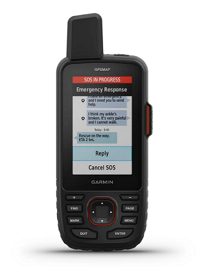
Why it Shines in Winter: Its brilliant 3-inch sunlight-readable display is easy to see in any condition, from blinding snow glare to the flat light of heavy overcast. The device provides up to 180 hours of battery life in GPS tracking mode and up to 840 hours in expedition mode, giving you weeks of navigation capability on a single charge. The button-based interface is a dream with thick gloves, featuring well-spaced controls that remain responsive even when covered in snow or ice.
The GPSMAP 67i utilizes multi-band GNSS technology, receiving signals from GPS, GLONASS, and Galileo satellites simultaneously across multiple frequency bands. This provides exceptional position accuracy—often within 3 meters—even in challenging environments like narrow valley bottoms or dense forest, both of which are common in winter hiking terrain.
The Killer Feature: Built-in two-way satellite messaging and SOS. Using the Iridium network, you can send and receive messages, trigger an SOS to GEOS Emergency Response, and even check the weather—all from deep in the backcountry, far from any cell signal. In winter, this feature is not a luxury; it’s a lifeline. The device offers up to 165 hours of battery life with inReach enabled using a 10-minute tracking interval, meaning you can maintain constant communication capability throughout extended winter expeditions.
The inReach functionality allows you to share your GPS location with loved ones via a tracking link they can follow on any web browser. You can preset messages for quick communication (saving battery), compose custom messages up to 1,600 characters, and receive weather forecasts specific to your GPS coordinates. The interactive SOS feature connects you directly with GEOS, a 24/7 emergency response coordination center staffed by professionals who can dispatch appropriate rescue services to your exact location.
Technical Specifications:
- Display: 3-inch color, sunlight-readable
- Memory: 16 GB internal storage
- Mapping: Preloaded TopoActive maps with routable roads and trails
- Connectivity: Bluetooth, ANT+, Wi-Fi
- Sensors: 3-axis compass, barometric altimeter
- Weight: 242 grams (8.5 ounces)
Best For: Serious winter hikers, mountaineers, ski tourers, and anyone who ventures beyond cell service and values ultimate safety. This device represents the pinnacle of handheld GPS technology and is particularly suited for solo adventurers or small groups traveling in avalanche terrain, glacier travel, or remote winter wilderness where self-rescue capabilities are essential.
Investment Consideration: While the GPSMAP 67i represents a significant investment (typically ranging from $600-$700), it combines multiple devices into one: GPS navigator, satellite communicator, emergency beacon, and weather station. The required inReach subscription (starting around $12-$15 per month for basic plans) is a recurring cost, but it provides invaluable peace of mind and communication capability that can be literally lifesaving in winter emergencies.
2. Garmin eTrex 32x: The Rugged, Affordable Workhorse
Don’t let the simple design fool you. The eTrex series has been a trusted companion for decades for a very good reason.
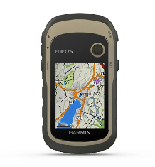
Why it Shines in Winter: It’s incredibly tough, waterproof (IPX7), and runs on 2 AA batteries for up to 25 hours of continuous use. The device operates reliably across a temperature range from -20°C to 70°C (-4°F to 158°F), making it suitable for everything from arctic winter camping to summer desert navigation. Its rocker and button interface is arguably the most glove-friendly on the market. It’s compact, lightweight at just 141.7 grams (5 ounces), and virtually indestructible.
The eTrex 32x has maintained its popularity precisely because of its simplicity and reliability. There’s no touchscreen to fail, no complex menu systems to navigate—just straightforward buttons that work every time, regardless of conditions. Lithium batteries perform better in cold weather compared to alkaline batteries, making them particularly valuable for winter hiking applications.
The Killer Feature: Price and Simplicity. You get reliable GPS/GLONASS/Galileo satellite tracking, a decent 2.2-inch color screen with 240 x 320 pixel resolution, and the essential “Breadcrumb trail” tracking without the high cost of more feature-rich models. It just works, every single time. The device includes a 3-axis tilt-compensated electronic compass and barometric altimeter, providing the core navigation tools you need without unnecessary complexity.
The eTrex 32x comes preloaded with TopoActive maps covering your region, showing terrain contours, elevation information, trails, and points of interest. The device has 8 GB of internal memory and supports microSD cards for additional map storage. You can create and follow routes, mark up to 2,000 waypoints, and save 200 track logs—more than sufficient for years of winter adventures.
Real-World Performance: The eTrex series has earned legendary status among search and rescue teams, professional guides, and ultralight backpackers. Its combination of affordability, durability, and reliability makes it an excellent choice for winter hikers who want proven technology without the complexity or cost of premium devices.
Technical Specifications:
- Display: 2.2-inch, 65K color
- Memory: 8 GB internal, microSD card slot
- Battery: 2 AA batteries (lithium recommended for winter)
- Sensors: 3-axis compass, barometric altimeter
- Weight: 141.7 grams (5 ounces) with batteries
Best For: Budget-conscious hikers, winter trail runners, and as a bomb-proof backup to your primary device. The eTrex 32x is also perfect for those new to GPS navigation who want to learn the fundamentals without being overwhelmed by features they may never use. Its sub-$300 price point (typically $250-$280) makes it accessible for recreational winter hikers who want reliable navigation without breaking the bank.
3. Garmin inReach Mini 2 (Paired with Your Phone): The Ultra-Light Safety Net
This is the ultimate “hybrid” approach. The Mini 2 is a tiny, lightweight satellite communicator with basic GPS capabilities designed to work in concert with your smartphone.
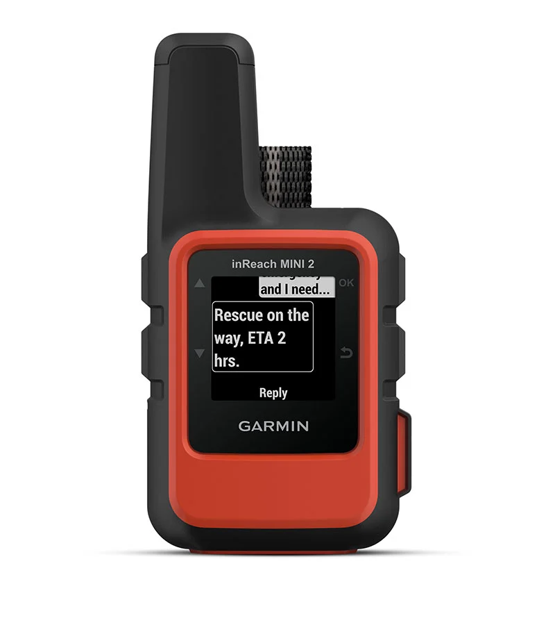
Why it Shines in Winter: It’s incredibly small (only 100 grams/3.5 ounces) and light, so you’ll always have it with you. It pairs with your phone via Bluetooth, allowing you to use the fantastic Earthmate app for detailed mapping on your phone’s large screen. This approach leverages the best aspects of both technologies: your phone’s superior display and interface when conditions permit, backed by the Mini 2’s satellite communication and GPS functionality when your phone fails.
The Killer Feature: Satellite SOS and Messaging in a tiny package. You can keep the Mini 2 warm in an inside pocket to preserve its battery while using your phone for navigation (keeping it in a warm pocket too, only pulling it out when needed). If your phone dies, the Mini 2 still works as a basic GPS and, most importantly, your emergency beacon.
The inReach Mini 2 provides up to 14 days of battery life at the default 10-minute tracking interval, or up to 30 days in power-saving mode with 30-minute intervals. This longevity means you can leave it on continuously throughout a winter trip, maintaining constant communication capability and tracking without battery anxiety.
The device allows two-way text messaging via satellite, enabling you to stay in touch with your support network even from the most remote locations. You can send and receive messages up to 1,600 characters, check weather forecasts, and most critically, trigger an SOS that alerts GEOS emergency response coordinators with your GPS coordinates.
Strategic Winter Use: The hybrid approach is particularly effective in winter conditions. Keep your smartphone in an interior pocket against your body where your body heat maintains battery performance. Use it for detailed navigation when needed, then return it to warmth. The inReach Mini 2 stays continuously on, providing tracking and emergency capability without the smartphone’s cold-weather vulnerabilities.
Technical Specifications:
- Display: Small LED indicator screen
- Battery: Rechargeable lithium-ion
- Weight: 100 grams (3.5 ounces)
- Communication: Two-way messaging via Iridium satellite network
- GPS: Basic GPS tracking (detailed navigation requires smartphone pairing)
Best For: Fast-and-light adventurers, ski tourers, winter ultrarunners, and anyone who wants the critical safety net of satellite communication without the bulk of a full-sized GPS. This device is ideal for those who already carry a smartphone and want to augment rather than replace it, or for weight-conscious travelers where every ounce matters.
Cost Consideration: The inReach Mini 2 typically retails for $400-$450, with required subscription plans starting around $12-$15 monthly. While this represents an investment, the combination of lightweight design and full-featured satellite communication makes it exceptional value for the safety-conscious winter traveler.
4. Garmin Montana 700 Series: The Big-Rig Navigator
For those who need a large, crystal-clear map view, the Montana is in a class of its own.
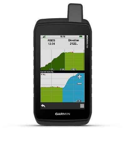
Why it Shines in Winter: It features a massive 5-inch glove-friendly touchscreen that also has hard buttons for full control—the best of both worlds. The large display uses a dual-orientation design that works in both portrait and landscape modes, allowing you to optimize your view based on terrain and route orientation. It’s built like a tank and is both waterproof (IPX7) and floatable (losing it in deep snow is a real concern!).
The Montana 700 series excels in situations where detailed map interpretation is critical. The large screen allows you to see multiple miles of terrain simultaneously, making route planning and terrain assessment far easier than on smaller displays. This is particularly valuable in winter when you need to identify potential hazards like avalanche terrain, cornices, or open water crossings that may be obscured by snow.
The Killer Feature: Screen Size and Versatility. The large, high-resolution (1280 x 720 pixels) display makes route-finding in complex, snow-covered terrain much easier. You can view multiple data fields simultaneously, split-screen mapping with elevation profiles, and still have plenty of screen real estate for clear map visualization. Some models (like the Montana 750i) also include inReach satellite communication, combining the large display advantages with emergency communication capability.
The Montana series includes a powerful quad-core processor that enables smooth panning and zooming even on detailed topographic maps. The device supports multiple map layers simultaneously, allowing you to overlay weather radar, satellite imagery, or custom waypoints on your base topographic map. This versatility is invaluable for complex winter navigation where multiple information sources inform safe route choices.
Real-World Applications: The Montana series shines in motorized winter travel (snowmobiling, over-snow vehicles), where it can be mounted on handlebars and viewed at a glance. It’s equally valuable for winter camping trips where you’re planning routes in your tent in the evening, or for search and rescue operations where multiple team members need to view and discuss routes on a large, clear display.
Technical Specifications:
- Display: 5-inch touchscreen, glove-capable
- Resolution: 1280 x 720 pixels
- Memory: 16 GB internal, microSD card slot
- Battery: Rechargeable lithium-ion or 3 AA batteries
- Sensors: 3-axis compass, barometric altimeter
- Weight: Approximately 350 grams (12.3 ounces)
- Connectivity: Bluetooth, ANT+, Wi-Fi
Best For: Over-snow vehicle trips (snowmobiling), complex route-finding in technical terrain, winter camping where route planning in camp is important, and hikers who prioritize a large, detailed map display above all else. The Montana is also excellent for groups where multiple people need to view the navigation device simultaneously, or for those with vision challenges who benefit from the larger display.
Investment and Value: The Montana 700 series ranges from $600-$750 depending on features (with the 750i model including inReach communication commanding the premium price). While expensive, the device replaces multiple tools: it serves as your GPS navigator, camera (8 megapixel), emergency communicator (750i model), and route planning computer. For serious winter adventurers or professional guides, this consolidation of tools justifies the investment.
Final Verdict: Navigating Your Choice
Choosing the right GPS for winter hiking depends on your specific needs, budget, and adventure style:
For Ultimate Safety & Performance: Garmin GPSMAP 67i. It’s the complete package for the serious winter adventurer who demands the highest level of safety technology. The combination of excellent GPS navigation, satellite communication, and extended battery life makes it the gold standard for remote winter travel.
For Value & Reliability: Garmin eTrex 32x. It’s the trusty, affordable, and un-killable companion that has proven itself over decades of use. If you want straightforward, dependable navigation without unnecessary complexity or cost, this is your device.
For Lightweight Emergency Preparedness: Garmin inReach Mini 2. The perfect safety net that you’ll never leave behind because it weighs less than four ounces. Ideal for those who want satellite communication capability without compromising their fast-and-light philosophy.
For Maximum Visibility and Versatility: Garmin Montana 700 Series. When you need the largest, clearest display possible and have the budget for premium features, the Montana delivers an unparalleled viewing experience.
Essential Winter Navigation Wisdom
No matter which device you choose, remember that a GPS is a tool, not a replacement for skill. Always carry a physical map and compass—and know how to use them. Your battery-powered guide is an incredible aid, but when technology meets a winter storm, low-tech redundancy is what truly brings you home safely.
Critical Backup Strategies:
- Master Traditional Navigation: Learn to use map and compass before relying on GPS. Practice taking bearings, triangulating your position, and following a compass bearing in conditions where you can verify your accuracy. These skills atrophy without use.
- Carry Spare Batteries: For devices using AA batteries, carry a spare set in an inside pocket where your body heat keeps them warm and ready. Cold batteries lose capacity but recover when warmed.
- Download Offline Maps: Ensure all necessary maps are downloaded to your device before entering the backcountry. Winter storms can strike with little warning, and you don’t want to discover you need cellular service to access critical mapping data.
- Mark Critical Waypoints: Before your trip, mark essential waypoints including your trailhead, key junctions, water sources (which may be frozen and hard to find), planned campsites, and bailout routes. In whiteout conditions, being able to navigate directly to a pre-marked waypoint can be lifesaving.
- Practice in Low-Stakes Conditions: Use your GPS on familiar trails in good weather to become proficient with its operation. Fumbling with an unfamiliar device in a storm while wearing gloves and fighting hypothermia is not the time to learn.
- Check Weather and Avalanche Forecasts: The best navigation tool is the knowledge to avoid dangerous situations entirely. Check forecasts before your trip, understand avalanche risk in your area, and be willing to change plans when conditions dictate.
- Tell Someone Your Plans: File a detailed trip plan with a trusted contact, including your planned route, expected return time, and emergency procedures. The best rescue technology in the world is worthless if no one knows you’re missing.
- Understand Your Device’s Limitations: GPS accuracy degrades in narrow canyons, beneath dense tree canopy, and occasionally in extreme cold. Don’t follow your GPS blindly—always verify its guidance against your map and terrain observations.
The Bottom Line
Winter hiking presents unique challenges that demand specialized equipment. Smartphone batteries can lose up to 20% of their capacity in freezing temperatures, making them unreliable as primary navigation tools in winter conditions. A dedicated GPS device designed for cold-weather use provides the reliability, battery life, and glove-friendly operation essential for safe winter navigation.
The investment in a quality GPS unit is an investment in your safety. When winter conditions turn hostile—and they will—having reliable navigation technology can mean the difference between a challenging adventure and a life-threatening emergency. Combined with proper training, physical maps, and sound judgment, a winter-capable GPS becomes an essential partner in exploring the profound peace and stark beauty of trails less traveled in winter.
Now get out there, be prepared, and enjoy the profound peace of a trail less traveled—in winter.
*) If you enjoyed this article, here are some related posts you might find interesting.