There’s nothing quite like it. That crisp snap in the air, the smell of damp earth and decaying leaves, and a mountainside painted in a blazing tapestry of red, orange, and gold. Fall foliage hiking is a spectacular experience that draws approximately ten million travelers to New England alone each year, with October serving as the peak month when over eighty percent of foliage enthusiasts embark on their autumnal adventures. However, this gorgeous season comes with a unique challenge: those dense canopies of color can also block your cell signal, leaving you with a useless phone and a potentially tricky situation.
That’s where a dedicated GPS device becomes your best trail buddy. Unlike your phone, these rugged units rely on satellite networks—connecting to GPS, GLONASS, Galileo, and other global navigation satellite systems—meaning they’ll guide you faithfully even when you’re deep in a crimson-covered gorge. Let’s explore the best GPS devices to ensure your autumnal adventure is all about the views, not the views of you getting lost.
Why Ditch the Phone for a Dedicated GPS?
We get it, your phone is amazing. But on a serious fall hike, it has several critical weaknesses that become especially problematic in autumn conditions:
Battery Life: Constantly searching for a signal and running mapping apps will drain your battery faster than you can say “peak color.” Modern smartphones typically struggle to provide more than seven to eight hours of active GPS use, while dedicated GPS devices can run for days or even weeks. Cold autumn temperatures further accelerate battery drain in smartphones, sometimes reducing battery life by thirty to fifty percent compared to summer conditions.
Signal Reliability: Thick foliage and remote locations are kryptonite for cellular service. Unlike smartphones that triangulate your position using cell towers before switching to GPS satellites, a dedicated GPS device doesn’t need a cell tower—it talks directly to satellites. Smartphones share GPS receiver components with cellular components to save costs, meaning they can’t maintain a continuous GPS fix while performing other functions. In contrast, dedicated GPS units ping satellites every thirty to sixty seconds, providing consistent location data even in areas with zero cellular coverage.
Durability and Precision: Professional-grade GPS devices are built to military standards for thermal, shock, and water performance. They feature quad-helix antennas and multi-band GNSS support, connecting to multiple satellite networks simultaneously for accuracy within three meters at least ninety-five percent of the time. This level of precision is crucial when navigating unmarked trails or finding that perfect hidden overlook for photographing peak foliage.
A good hiking GPS gives you peace of mind, extended battery life measured in days rather than hours, and pre-loaded topographic maps that show you the lay of the land in incredible detail—complete with contour lines, elevation profiles, and waypoint marking capabilities that far exceed smartphone applications.
The Top Contenders for Your Leaf-Peeping Trek
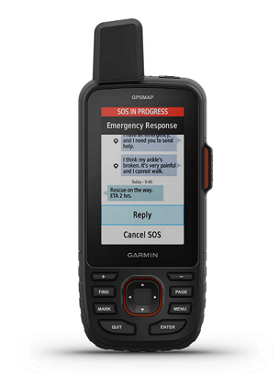
1. The All-Around Champion: Garmin GPSMAP 67i
Best For: The hiker who wants the ultimate in reliability and safety.
Price Range: Approximately $600-$700
The GPSMAP 67i is a powerhouse that has earned recognition as the best-selling GPS unit from Garmin and the top-rated handheld GPS device of 2025. Released in February 2024, it builds on Garmin’s legendary reputation for accuracy with a feature that’s a game-changer for solo hikers or those venturing into the deep backcountry: built-in satellite messaging and SOS capabilities.
Technical Specifications:
- Battery Life: Up to 165 hours in tracking mode (10-minute intervals) and up to 425 hours in expedition mode (30-minute tracking intervals)
- Satellite Networks: Multi-band GNSS support including GPS, GLONASS, Galileo, QZSS, BeiDou, and IRNSS
- Display: 3-inch sunlight-readable color display
- Weight: 8.1 ounces
- Durability: Military-grade construction (MIL-STD-810) for thermal, shock, and water performance
- Maps: Preloaded TopoActive maps for North America with routable roads and trails
Why it’s great for foliage season: Its multi-band GPS technology is incredibly accurate, cutting through tree cover to pinpoint your location even under the densest autumn canopies. According to outdoor gear testers, the unit maintains satellite connection even in less-than-ideal locations like dense forests and tight slot canyons. The screen is sunlight-readable, so you won’t be squinting when the low-angle autumn sun creates challenging lighting conditions. The built-in LED flashlight serves double duty as both a practical tool for navigating dim forest trails and a beacon to signal for help in emergencies.
Using the one hundred percent global Iridium satellite network, you can send and receive text messages for peace of mind or trigger an interactive SOS to the Garmin Response center, a 24/7 professional search and rescue monitoring coordination center with over 10,000 successful rescues worldwide. The device also supports the Garmin Explore app for trip planning, waypoint management, and optional Outdoor Maps+ subscription for enhanced mapping features including land ownership boundaries, hunting management units, and detailed terrain shading.
The Trade-off: It’s an investment at the premium end of the market. Additionally, the satellite communication features require an active inReach subscription plan (monthly or annual options available), which adds to the operational cost. However, for serious outdoor enthusiasts who regularly venture into remote backcountry areas, the combination of navigation accuracy and communication capability makes it potentially life-saving equipment.
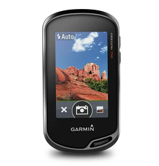
2. The Touchscreen Trailblazer: Garmin Oregon 750
Best For: The tech-savvy hiker who loves a smartphone-like experience with rugged reliability.
Price Range: Approximately $400-$500 (Note: This model has been discontinued but remains available through retailers)
If you prefer the pinch-and-zoom familiarity of a smartphone, the Oregon 750 is your perfect match. It features a responsive, glove-friendly touchscreen with 240 x 320 pixel resolution that makes navigating maps a breeze. This model revolutionized handheld GPS navigation by combining touchscreen convenience with traditional button controls, giving users the flexibility to choose their preferred input method.
Technical Specifications:
- Battery Life: Up to 16 hours with rechargeable NiMH battery pack or dual AA batteries
- Display: 3-inch transflective color touchscreen with dual orientation (landscape or portrait)
- Camera: 8-megapixel autofocus camera with automatic geotagging
- Weight: 7.4 ounces with batteries
- Connectivity: Wi-Fi, Bluetooth, and ANT+ capability
- Waterproof Rating: IPX7
- Memory: 4GB internal storage plus microSD card slot
- Sensors: 3-axis electronic compass with barometric altimeter
Why it’s great for foliage season: The dual-orientation screen works in portrait or landscape mode, perfect for examining long trail routes or detailed topographic profiles when planning your approach to high-elevation vistas. The touchscreen makes panning and zooming through colorful autumn maps intuitive and fast—a significant improvement over button-only navigation on older models. You can geotag your best fall foliage shots directly from the device using the built-in 8-megapixel camera, automatically creating waypoints so you can navigate back to that perfect photo spot in future years.
The device connects to your smartphone via Bluetooth for smart notifications, allowing you to receive texts and emails if you wander into a rare patch of service. The wireless connectivity also enables automatic cache updates from Geocaching Live, Active Weather support with animated radar overlays, and seamless data sharing with the Garmin Connect online community. The enhanced antenna provides better satellite reception compared to earlier models, improving performance in challenging environments.
The Trade-off: Touchscreens can be less responsive with wet fingers—a common occurrence during dewy morning hikes or in drizzly autumn weather. The 16-hour battery life is considerably shorter than button-based models, so carrying spare AA batteries or a rechargeable battery pack is essential for longer expeditions. Some users report that the processor is slower than higher-end models, and the touchscreen may become unresponsive when the device gets wet, which is the unavoidable downside of any touchscreen in outdoor conditions.
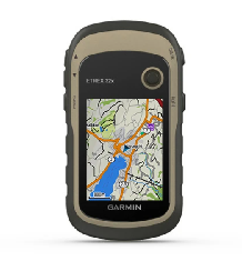
3. The Budget-Friendly Powerhouse: Garmin eTrex 32x
Best For: The value-conscious hiker who needs reliable, no-frills navigation.
Price Range: Approximately $300
Don’t let the simple design fool you—the eTrex 32x is a workhorse that performs well beyond its weight class compared to more expensive models. It’s one of the most affordable ways to get a high-sensitivity GPS receiver with a color screen and preloaded TopoActive maps for North America.
Technical Specifications:
- Battery Life: Up to 25 hours in GPS mode with 2 AA batteries
- Display: 2.2-inch sunlight-readable color display (240 x 320 pixels)
- Weight: 5 ounces (142 grams)
- Satellite Support: GPS and GLONASS dual-satellite reception
- Memory: 8GB internal storage plus microSD card slot
- Sensors: 3-axis compass and barometric altimeter
- Maps: Preloaded TopoActive maps with routable roads and trails
Why it’s great for foliage season: It’s small, lightweight, and incredibly tough—perfect for hikers who want to minimize gear weight while maximizing reliability. The button-based joystick interface is easy to use even with gloves on, making it ideal for chilly autumn mornings when temperatures hover around freezing. It runs on two readily available AA batteries, which you can swap out in seconds for virtually unlimited power in the field. The device supports both GPS and GLONASS satellite systems, allowing it to track in more challenging environments than GPS alone, including under dense fall canopies and in deep valleys.
The preloaded TopoActive maps provide adequate detail for most hiking scenarios, including urban and wilderness trails, contour lines, water features, and points of interest. The impressive navigational accuracy results from linking multiple satellite networks to identify your specific location, enhanced by the barometric altimeter for precise elevation tracking and a 3-axis digital compass that maintains bearing even when stationary. The bright yellow and red casing is also easy to spot if you set it down on a log covered in fallen leaves.
The Trade-off: The screen is smaller (2.2 inches versus 3 inches on premium models) and lower resolution than flagship devices, prioritizing function over visual flair. The processor is slower than higher-end handhelds, meaning map rendering and route calculations take a few extra seconds. While the device excels at basic navigation, it lacks advanced features like satellite messaging, Wi-Fi connectivity, and camera functionality. For hikers focused on reliable trail navigation without bells and whistles, these limitations are minor—but those seeking a comprehensive outdoor tool may find it restrictive.
4. The Adventurer’s Watch: Garmin fenix 7 / Epix (Gen 2)

Best For: The ultralight hiker or runner who wants navigation on their wrist.
Price Range: fenix 7: $600-$1,000 depending on size and features; Epix Gen 2: $900-$1,000
Why carry a device when you can wear one? High-end multisport watches like the Garmin fenix 7 and its sibling, the Epix Gen 2, are incredible navigation tools that combine comprehensive mapping capabilities with advanced fitness tracking. Released simultaneously on January 18, 2022, these watches represent the pinnacle of wrist-based outdoor navigation technology.
Technical Specifications (Epix Gen 2):
- Display: 1.3-inch AMOLED touchscreen with 416 x 416 resolution
- Battery Life: Up to 6 days in smartwatch mode, up to 30 hours in GPS mode
- Case Size: 47mm (single size available)
- GPS: Multi-band GNSS (GPS, GLONASS, Galileo) for enhanced accuracy
- Maps: Full-color TopoActive maps with touchscreen navigation
- Sensors: Barometric altimeter, 3-axis compass, accelerometer
- Water Rating: 10 ATM (100 meters)
Technical Specifications (fenix 7):
- Display: Transflective screen (260 x 260 pixels on standard size)
- Battery Life: Up to 18 days in smartwatch mode, up to 57 hours in GPS mode
- Available Sizes: 42mm (fenix 7S), 47mm (fenix 7), 51mm (fenix 7X)
- Solar Options: Available on select models for extended battery life
- GPS: Multi-band GNSS on Sapphire editions
Why it’s great for foliage season: The convenience is unmatched—a quick glance at your wrist shows your trail route, direction, and distance to your next waypoint without fumbling in your pack for a handheld device. The battery can last for days, even with GPS active tracking every second of your hike. Solar-charging versions of the fenix 7 can harness even weak autumn sunlight to extend battery life further, with some models achieving up to 37 days in smartwatch mode with solar charging enabled.
The Epix Gen 2’s vivid AMOLED display makes map viewing exceptionally clear, with considerably higher detail than the fenix 7 due to its superior 416 x 416 resolution screen. This high-resolution display translates to sharper map details and better visibility of trail routes, waypoints, and topographic features. The touchscreen interface makes panning, scrolling, and zooming maps intuitive and fast—a significant advantage when you need to quickly check your position or adjust your route during a hike.
Both watches feature the “Up Ahead” navigation function that displays upcoming waypoints with distance, name, and icon information in a single glanceable page. This is incredibly helpful on fall hikes for maintaining context about your progress without constantly opening the full map. The built-in barometric altimeter accurately tracks elevation gain, which is key for finding those high-elevation vistas where foliage views are most spectacular.
The Trade-off: The small screen (even at 1.3 to 1.4 inches) isn’t ideal for intensive route planning on the fly. Most users plan routes on a computer or smartphone before syncing them to the watch. The Epix Gen 2’s bright AMOLED display is power-hungry, requiring charging approximately every six days compared to the fenix 7’s two-week battery life. However, for serious adventurers accustomed to charging devices regularly, the Epix’s superior screen quality may justify the more frequent charging. The fenix 7 offers better battery efficiency but with a lower-resolution display that some users find less vivid and harder to read in certain lighting conditions. These watches are best used in tandem with a larger device for detailed planning or for following pre-planned routes where you need quick navigational context rather than comprehensive map analysis.
Your Fall Foliage GPS Checklist
Before you hit the trail to chase those breathtaking autumn colors, make sure you’re prepared with these essential steps:
Pre-Load Your Route: Don’t wait until you’re at the trailhead when signal may be weak or nonexistent. Plan your route on your computer at home using applications like Garmin Explore, Gaia GPS, CalTopo, or AllTrails, then sync it to your device via USB cable or wireless connection. Many GPS apps now include satellite imagery overlays that can show recent foliage conditions, helping you identify areas where color may already be past peak or not yet developed. Take time to review topographic features, elevation profiles, and trail junctions to familiarize yourself with the terrain.
Mark Key Waypoints: Pinpoint the parking lot, scenic overlooks, water sources, trail junctions, emergency shelter locations, and your planned turn-around point. This creates a digital breadcrumb trail back to safety and helps you track progress throughout your hike. Include elevation data in your waypoints to better anticipate viewpoints—in mountainous regions, elevation differences of just 500 to 1,000 feet can dramatically change foliage progression, with higher elevations peaking earlier in the season.
Download Offline Maps: Even with a dedicated GPS device, having detailed offline maps ensures you have backup navigation data if your primary device malfunctions. Most modern devices support additional map downloads via microSD cards or internal storage. Consider downloading satellite imagery overlays and specialized maps like hunting unit boundaries or land ownership maps if hiking on mixed public-private lands.
Test Your Device: Before departing on a major foliage expedition, take your GPS device on a shorter local hike to familiarize yourself with its operation. Practice functions like creating waypoints, following a preloaded route, marking your location, and understanding the various screen displays. Knowing how to quickly access critical functions like the man-overboard feature or SOS button can prove invaluable in emergency situations.
Bring a Power Bank: Even with great battery life measured in days or weeks, a small power bank (5,000-10,000 mAh capacity) is cheap insurance for longer trips, especially when October temperatures can drain batteries faster than expected. Many modern GPS devices now feature USB-C charging, making them compatible with standard power banks. For watches, consider a lightweight solar charger for multi-day expeditions.
Check Satellite Communication Subscriptions: If your device features inReach or similar satellite communication capabilities, verify that your subscription is active and understand your message limits before departure. Consider upgrading to a higher-tier plan if you anticipate needing frequent communication during an extended foliage road trip or backpacking adventure.
Calibrate Your Compass and Altimeter: Most GPS devices with electronic compasses and barometric altimeters benefit from calibration before use. Follow manufacturer instructions to calibrate the compass by rotating the device through all orientations, and set the altimeter to a known elevation at your trailhead for accurate elevation tracking throughout your hike.
Don’t Forget a Paper Map & Compass: Technology can fail due to battery depletion, water damage, accidental drops, or extreme cold. A waterproof paper map and compass—along with the knowledge and practice to use them—are your ultimate backup plan. Understanding basic navigation skills including taking bearings, triangulation, and reading topographic contours ensures you can find your way home even if all electronic navigation fails. Consider laminated maps or storing paper maps in waterproof cases to protect against autumn rain and morning dew.
Dress in Layers and Prepare for Changing Conditions: Fall weather is notoriously unpredictable, with morning temperatures potentially thirty to forty degrees cooler than afternoon highs. Pack extra layers, rain gear, and be prepared for sudden weather changes that can impact visibility and trail conditions. Keep your GPS device insulated in an inside pocket during extreme cold to preserve battery life.
Understanding GPS Technology for Fall Conditions
The science behind GPS navigation becomes particularly relevant during fall foliage season. GPS (Global Positioning System) relies on a network of approximately 24 active satellites orbiting Earth. Your GPS device acts as a receiver, requiring signals from at least three satellites to triangulate your position in two dimensions, or four satellites for three-dimensional positioning including altitude. The more satellites your device connects with, the greater the accuracy and speed of the location fix.
Modern handheld GPS devices connect to multiple Global Navigation Satellite Systems (GNSS) including GPS (United States), GLONASS (Russia), Galileo (European Union), BeiDou (China), QZSS (Japan), and IRNSS (India). This multi-constellation capability is crucial during fall foliage season when dense canopies can partially obstruct sky visibility. With more satellite networks available, your device maintains positioning accuracy even when line-of-sight to some satellites is blocked by autumn leaves.
Multi-band GPS technology, featured in premium devices like the GPSMAP 67i and fenix 7 Sapphire editions, represents the latest advancement. These devices can receive signals on multiple frequencies (L1 and L5 bands) from satellite systems, allowing them to better compensate for signal reflections and obstructions. In practical terms, this translates to significantly improved accuracy in challenging environments—exactly the conditions you encounter when hiking through dense deciduous forests at peak color.
The Wide Area Augmentation System (WAAS) further enhances accuracy by correcting errors in GPS data, achieving location precision within three meters at least ninety-five percent of the time. This level of accuracy is sufficient for marking specific photo locations, identifying trail junctions, and creating detailed track logs of your foliage hikes.
Conclusion: Choosing Your Perfect Foliage Navigation Companion
This fall, don’t just follow the leaves—navigate them with confidence. With the right GPS device in your pack or on your wrist, you can immerse yourself in the breathtaking beauty of the season, knowing you have the technology to find your way home, long after the last leaf has fallen.
When selecting your GPS device, consider your specific needs:
- For comprehensive safety and communication: Garmin GPSMAP 67i
- For touchscreen convenience with solid features: Garmin Oregon 750
- For budget-conscious reliability: Garmin eTrex 32x
- For lightweight wrist-based navigation: Garmin fenix 7 or Epix Gen 2
Remember that approximately ten million people venture out each fall to experience peak foliage, with trails becoming increasingly crowded during October’s prime viewing weeks. Having reliable navigation not only keeps you safe but allows you to discover those hidden, less-crowded vistas where you can experience autumn’s glory in peaceful solitude.
Whether you’re planning a day hike through the White Mountains of New Hampshire, a multi-day backpacking trip through Vermont’s Green Mountains, or a scenic drive with short walks through North Carolina’s Blue Ridge Parkway, investing in a quality GPS device transforms your fall foliage adventures from potentially anxious navigation challenges into confident explorations of nature’s most spectacular seasonal display.
Happy Trails!
*) If you enjoyed this article, here are some related posts you might find interesting.