Winter transforms familiar landscapes into beautiful but treacherous territory. When snow blankets roads, trails, and landmarks, your usual navigation instincts can fail. Your smartphone or car’s GPS becomes a lifeline—but only if you use it wisely. Recent data reveals that winter driving conditions contribute to approximately 156,000 crashes annually due to icy roads, with over 1,300 fatalities and 116,000 injuries each year in the United States. Moreover, a 2024 study published in PLOS ONE identified 90 incidents between 2010 and 2023 where GPS systems misled drivers into dangerous situations. Here’s how to master winter navigation and ensure you get home safely, no matter what the weather throws at you.
1. Pre-Trip Prep: Your Digital Winterization
Before you even step out the door, set your tech up for success. The difference between a safe journey and a dangerous situation often comes down to preparation.
Download Offline Maps: Cellular service is notoriously unreliable in winter storms and remote snowy areas. Google Maps offers an offline feature that allows users to download entire regions for navigation without internet connectivity. To download offline maps on Google Maps, open the app, tap your profile picture, select “Offline maps,” then choose “Select your own map” and adjust the area you want to download. Maps automatically update when connected to Wi-Fi and expire after one year if not updated. Alternative apps like Gaia GPS and AllTrails are specifically designed for outdoor navigation and offer superior topographic detail.
Gaia GPS Premium costs approximately $40 per year and provides access to over 300 map layers, including National Geographic Trails Illustrated series, winter maps, and real-time weather overlays. The app’s offline functionality is crucial for backcountry navigation where cellular service is unavailable. AllTrails Plus, priced at around $36 annually, offers a more user-friendly interface with its extensive database of over 100,000 curated trails, user reviews, and GPS tracking capabilities. Both platforms allow users to record their exact path, create waypoints, and access detailed elevation profiles.
Update Everything: Ensure your GPS device, smartphone apps, and car infotainment system have the latest software and map updates. Outdated maps are a documented safety hazard—a systematic analysis of 158 catastrophic GPS-related incidents from 2002 to 2016 found that missing or incorrect road attributes contributed to 64 cases, with vehicles often routed onto closed roads, demolished structures, or non-existent paths. The Snow Creek Bridge in North Carolina, which collapsed in 2013, remained depicted as passable on Google Maps through 2023, leading to at least one fatal accident. In November 2024, three men died in India after Google Maps directed their vehicle off an incomplete bridge into a riverbed due to unmapped construction status.
Check Road Conditions: GPS algorithms prioritize the fastest route, not necessarily the safest one. Cross-reference with state Department of Transportation websites like 511 systems or apps like Waze, which incorporates user-reported road condition features. Research shows that 24% of weather-related vehicle crashes occur on snowy, slushy, or icy pavement, while 15% happen during snowfall or sleet. In Michigan alone, winter weather conditions accounted for 22,713 crashes during the 2023-2024 winter season, resulting in 36 fatal crashes and 3,938 injuries. Understanding current road conditions can mean the difference between arriving safely and becoming part of these statistics.
2. In the Car: Be Smarter Than Your Dashboard
Your car GPS is a co-pilot, not the captain in a snowstorm. Understanding its limitations is crucial for winter safety.
Beware the “Shortcut”: GPS navigation may direct you down seasonal roads that aren’t plowed or maintained in winter. The National Highway Traffic Safety Administration has identified GPS navigation as one of the worst in-car electronic device distractions, with programming a GPS while driving being more dangerous than texting. Research from the United Kingdom indicates that in-car GPS devices have caused an estimated 300,000 car accidents in that country alone. Extrapolating to the United States with its larger driving population suggests GPS-related accidents may number in the millions.
In your vehicle settings, select “Avoid Unpaved Roads” if available, and exercise common sense—if a route looks suspiciously rural or unfamiliar, verify it through alternate sources. GPS apps don’t account for construction zones, new traffic patterns, weather conditions, or temporary situations that require extra caution. The 2024 PLOS ONE study found that half of GPS-induced traffic disruptions were traffic jams, while a third were caused by heavy vehicle through-traffic on roads not designed for such volumes.
Power is Paramount: Keep your phone and any dedicated GPS units charged. Cold weather dramatically impacts battery performance—lithium-ion batteries, which power most smartphones, experience significant capacity loss below 32°F (0°C). Scientific research shows that cold temperatures slow the chemical reactions inside batteries, causing ions to move more slowly through the electrolyte. At temperatures below zero, battery capacity can drop by 20% or more. In extreme tests at -10°C, most phones drain their batteries completely in approximately 90 minutes, while at -30°C, devices shut down in less than 15 minutes.
Use a car charger during travel, but also carry a high-capacity portable power bank rated for at least 10,000mAh in case you’re stranded and need to conserve your vehicle’s battery. Keep power banks warm in an interior pocket, as they too suffer from cold-weather performance degradation. Modern devices like the Garmin inReach communicators feature batteries that can last for weeks in tracking mode, making them ideal backup navigation tools.
Old-School Backup: Stash physical paper maps or a road atlas in your glove box. They don’t run out of batteries and provide broader geographical context that a small screen cannot. Despite our technological advances, traditional navigation tools remain invaluable when digital systems fail. Search and rescue professionals consistently emphasize the importance of carrying paper maps and knowing how to use them, particularly in wilderness areas where a single GPS malfunction could prove life-threatening.
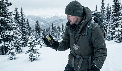
3. On the Trail: Navigation for Snowshoers and Skiers
Winter recreation requires next-level navigation tactics. The stakes are higher in backcountry environments where help may be hours or days away.
Use a Purpose-Built App: AllTrails, Gaia GPS, or FatMap are excellent for trails. A 2025 comparison of hiking apps reveals that Gaia GPS is generally preferred by experienced backcountry users for its accuracy and detailed topographic information, while AllTrails excels in trail discovery and community engagement for more popular routes. However, experts caution that AllTrails’ crowd-sourced routes can be inaccurate, with unmarked trails that were easy to follow in summer becoming impossible to navigate after snowfall.
Key features to use:
Record Your Track: Start tracking when you begin your journey. Your exact path in the snow becomes your most reliable route back. GPS tracking creates a digital breadcrumb trail that remains accessible even if visual landmarks disappear under fresh snowfall. Both Gaia GPS and AllTrails allow users to export GPX files for backup purposes and sharing with emergency contacts.
Place Waypoints: Mark your starting point, the vehicle, and any key turns. On a white-out day, finding your way back to a specific trailhead can be surprisingly difficult. Professional mountaineers and search and rescue teams emphasize waypoint marking as a critical safety practice. Digital waypoints act as virtual signposts that remain accessible regardless of weather conditions or visibility.
Protect Your Phone from the Elements: Cold kills battery life dramatically. Research from Gaia GPS and outdoor safety experts recommends keeping your phone in an inner pocket close to your body for warmth. Body heat can extend battery life significantly—some users report differences of several hours between phones kept warm versus those exposed to freezing temperatures. Consider investing in a weather-resistant thermal case like those offered by Phoozy, which uses NASA-developed Chromium Thermal Barrier technology to extend battery life up to four times in cold conditions.
Turning on airplane mode conserves battery if you’re only using the GPS radio, which doesn’t require cellular connectivity. Navigation apps like Gaia GPS and AllTrails rely on GPS satellite signals for positioning, which function independently of cellular networks. Disable Bluetooth, Wi-Fi, and location services for non-essential apps. Lower screen brightness to minimum readable levels, as display illumination is one of the largest battery drains. Studies show that decreasing brightness can save up to 20% of battery life.
The White-Out Rule: If visibility drops to zero, don’t rely solely on GPS. Stop, seek shelter, and use your device to communicate your coordinates if you need help. Modern smartphones with iPhone 14 and newer models include Emergency SOS via satellite features that enable messaging with emergency services when outside cellular and Wi-Fi coverage. This technology, powered by Globalstar’s satellite network, has been credited with saving numerous lives, including hikers stranded during wildfires in British Columbia and lost adventurers in remote Alaska.
4. Essential Winter-Specific GPS Settings & Hacks
Understanding your device’s capabilities and limitations in winter conditions maximizes safety and reliability.
Calibrate Your Compass: Snow and metal can interfere with compass accuracy. In your phone’s sensor settings, often found in the map app, recalibrate the compass by moving your device in a figure-eight motion. This process resets the magnetometer and improves directional accuracy. Search and rescue professionals recommend compass calibration before every backcountry trip, as even slight inaccuracies can lead to significant navigation errors over distance.
Brightness to Max: In snowy, bright conditions with intense sun reflection, you’ll need your screen brightness at maximum to see it clearly. Snow blindness from reflected UV radiation can reduce visibility, making screen readability crucial. However, maximum brightness drains batteries considerably faster—another compelling reason for that portable power bank. Balance visibility needs with battery conservation by using temporary brightness boosts only when actively navigating.
Know Your SOS Features: Both iPhone and Android devices have built-in emergency capabilities that can save lives. iPhone 14, 15, and 16 models feature Emergency SOS via satellite, which allows users to text emergency services when off-grid without cellular or Wi-Fi coverage. Available in 18 countries including the United States, Canada, Australia, and most of Europe as of late 2024, this feature has contributed to rescuing stranded hikers, accident victims, and lost adventurers.
The system works by connecting to one of Globalstar’s 24 satellites in low-earth orbit, which then relay messages to custom ground stations that route them to emergency services. Apple’s $450 million investment in satellite infrastructure has enabled this potentially life-saving technology, which is included free for two years with iPhone activation. The service has already been activated more than 14,500 times, resulting in numerous documented rescues.
For Android users, newer flagship devices from Samsung and Google also offer satellite SOS features in select markets. Additionally, dedicated satellite communicators like the Garmin inReach series provide more robust two-way communication capabilities. The newest Garmin inReach Messenger Plus, introduced in September 2024 at $499.99, offers photo and voice messaging in addition to traditional text communication, with a battery life that can last for weeks or even up to a year depending on usage mode.
5. The Ultimate Winter Navigation Kit
Technology is brilliant, but winter demands redundancy. Your comprehensive navigation kit should include multiple backup systems to ensure you can always find your way.
Primary: Smartphone with offline maps and a full battery. Modern smartphones running Gaia GPS Premium or AllTrails Plus with downloaded offline maps covering your entire planned route and surrounding areas. Ensure your phone is fully charged before departure—start at 100% battery capacity.
Secondary: A dedicated handheld GPS device like the Garmin inReach Mini 2 (weighing just 3.5 ounces) or Oregon series provides superior ruggedness and extended battery life compared to smartphones. The inReach Mini 2 features up to 14 days of battery life in standard 10-minute tracking mode and extends to 30 days on 30-minute tracking intervals. These devices are built to military standards (MIL-STD-810) for durability and are water-resistant to IPX7, meaning they can withstand immersion up to 1 meter for 30 minutes.
Garmin’s inReach devices operate on the Iridium satellite network, providing truly global coverage with no gaps. Unlike geosynchronous satellites used by some competitors, Iridium’s constellation consists of satellites in low-earth orbit moving at approximately 16,000 mph, ensuring coverage even in polar regions where other systems fail. The two-way text messaging capability, interactive SOS alerts to Garmin Response coordination centers (staffed 24/7), and real-time weather updates make these devices invaluable for serious backcountry travel.
Backup: A physical compass and detailed paper topographic map of the area. Know how to use them. Traditional navigation skills remain essential—batteries die, electronics fail, and screen damage can render digital devices useless. The Silva Ranger compass or Suunto MC-2 are professional-grade instruments trusted by mountaineers and search and rescue teams worldwide. Pair your compass with waterproof topographic maps printed on synthetic paper that won’t tear or dissolve when wet.
Power: Multiple portable chargers rated at 10,000-20,000mAh capacity, multiple charging cables (USB-C, Lightning, micro-USB as needed), and wall adapters. Consider solar chargers for extended trips, though be aware that winter’s shorter days and frequent cloud cover reduce solar charging efficiency. The Battarix emergency power supply offers an eight-year shelf life and provides crucial backup charging capacity in true emergencies.
Safety: A reliable personal locator beacon (PLB) or satellite communicator for true wilderness travel. While PLBs like the ACR ResQLink transmit one-way distress signals to international search and rescue satellites, two-way communicators like the Garmin inReach series allow ongoing communication with rescue coordinators and loved ones. The ability to provide situation updates, receive instructions, and confirm that help is en route can significantly improve rescue outcomes and reduce anxiety for both victims and their families.
Final Word: Trust Your Instincts Over the Algorithm
GPS is a tool, not an oracle. The technology, while powerful, lacks human judgment and contextual awareness. If your gut says the plowed interstate is safer than the GPS-recommended “10 minutes faster” backroad, listen to your gut. Research consistently shows that driver over-reliance on GPS contributes to thousands of accidents annually, with people ignoring warning signs, detour barricades, and obvious hazards because “the GPS said so.”
Courts typically place responsibility on drivers rather than GPS companies, as navigation apps protect themselves with broad liability disclaimers buried in user agreements. However, the 2024 case of Philip Paxson, who died after driving off a collapsed bridge in North Carolina while following Google Maps directions, has sparked legal discussions about potential GPS provider liability when apps fail to update critical infrastructure data despite repeated user reports.
Winter navigation is about layering information: real-time road conditions from official sources, weather forecasts, technology-provided routing, local knowledge when available, and human judgment synthesizing all these inputs. The Federal Highway Administration notes that the first snowfall of the season is significantly more dangerous than subsequent storms, as drivers and road systems are unprepared for winter conditions.
Prepare your technology meticulously, pack multiple backup systems, understand your devices’ limitations in cold weather, and develop the judgment to know when to deviate from digital recommendations. Modern GPS technology combined with proper preparation and sound decision-making creates the optimal winter navigation strategy.
Stay Found, Stay Safe, and Happy Winter Travels!
*) If you enjoyed this article, here are some related posts you might find interesting.