You’re gearing up for an adventure. The trailhead is calling, the wilderness is waiting, and your pack is almost ready. But there’s one crucial decision left: how will you find your way? In one corner, you have the sleek, space-age technology of a GPS device or smartphone. In the other, the timeless, trusty combo of a map and compass.
This isn’t just a debate for old-school scouts and tech geeks. It’s a fundamental question of safety, skill, and preparedness that has taken on new urgency as rescue statistics show concerning trends in navigation-related incidents. So, which one do you really need? The answer might surprise you: you need both. But let’s break down why, backed by the latest data and real-world performance metrics.
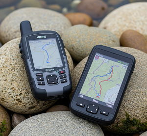
The Digital Powerhouse: GPS
A GPS (Global Positioning System) receiver is a modern marvel that has undergone significant improvements in recent years. It talks to a constellation of satellites orbiting the Earth to pinpoint your exact location anywhere on the planet, anytime, in almost any weather. With 2024’s major accuracy improvements reducing signal errors by approximately 30%, GPS technology has never been more reliable.
Why You’ll Love It:
Pinpoint Accuracy: Modern GPS devices achieve remarkable precision. GPS-enabled smartphones are typically accurate to within 4.9 meters (16 feet) under open sky conditions, while high-end handheld units like the Garmin GPSMAP 67 series offer even greater accuracy through quad-helix antennas and multi-constellation satellite reception. You are the blue dot on the map—there’s no guessing. This precision is invaluable for confirming you’re on the right trail, especially at confusing intersections or in featureless terrain like dense forests or desert landscapes.
Ease of Use: For the average person, downloading a trail on popular apps has become incredibly straightforward. AllTrails, which excels at trail discovery and community features, offers detailed information, user reviews, and real-time trail condition updates. Meanwhile, Gaia GPS provides more comprehensive navigation tools for serious backcountry exploration. The 2025 introduction of AI-driven features, including custom route builders and hyper-detailed trail condition predictions for factors like snow depth and mosquito activity, has revolutionized trip planning.
Loaded with Data: Digital maps can show you everything: your speed, distance traveled, elevation gained, and even upcoming points of interest. Many allow you to drop pins for cool campsites or water sources. Modern apps integrate weather forecasts, permit requirements, and even crowd-sourced trail conditions updated by fellow hikers in real-time.
Track Recording: GPS devices automatically create a breadcrumb trail of your route, storing waypoints and creating a detailed log of your journey. If you get turned around, you can literally hit “Track Back” to reverse your steps. This feature has proven invaluable in search and rescue operations, where rescue teams can analyze a missing person’s last known track to focus their efforts more effectively.
Advanced Connectivity Features: Many modern GPS devices now offer satellite communication capabilities, allowing users to send SOS signals or check-in messages even when completely off-grid. This technology has already saved countless lives in remote wilderness areas.
Where It Falls Short:
The Battery Problem: This remains the Achilles’ heel of digital navigation. No battery, no navigation. Cold weather can reduce battery life by 40-60%, and if you’re out for multiple days, keeping devices charged becomes a complex logistical puzzle. Even the most efficient devices require daily charging during extended backcountry trips.
Signal Failure: While increasingly rare with improved satellite coverage, signals can still be lost in deep canyons, under heavy canopy cover, or due to technical issues. The U.S. Coast Guard’s GPS Problem Reporting system tracks these incidents, showing that geographic features like steep canyon walls and atmospheric conditions can still cause temporary signal loss. If you’ve put all your faith in that blue dot, its disappearance can be genuinely paralyzing.
The Big Picture Blindspot: Staring at a small screen can make you miss the grand landscape around you and prevent you from developing crucial terrain association skills. You might follow the line on the screen without learning to read the actual landscape, making you a less competent navigator overall and potentially more vulnerable when technology fails.
User Error and Over-Reliance: Statistics from mountaineering organizations show that over 40% of hikers who use GPS have experienced situations where their device failed or provided incorrect information. Common issues include putting in wrong coordinates, misreading the interface, not understanding map datum settings, or failing to download offline maps before entering areas without cell coverage.
Security Vulnerabilities: Modern GPS systems face emerging threats from jamming and spoofing, particularly in certain geographic regions. While rare in typical hiking scenarios, these vulnerabilities represent a growing concern for outdoor navigation reliability.
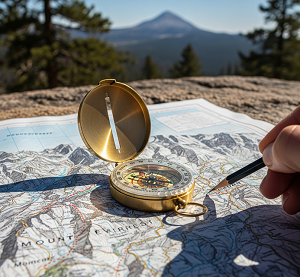
The Analog Classic: Map & Compass
This traditional navigation duo requires no satellites, no batteries, and no signal. It represents navigation in its purest form, relying entirely on your skill, knowledge, and understanding of the natural world around you.
Why It’s Timeless:
Ultimate Reliability: Paper doesn’t run out of power, and a quality compass will function for decades with minimal maintenance. These tools are immune to technical glitches, electromagnetic pulses, cyber attacks, or solar flares. They will work flawlessly on day 10 of your trek just as well as on day one, regardless of weather conditions or technological failures.
Forces Situational Awareness: Using a map and compass requires constant engagement with your environment. You must continuously look up and match the features on paper to the world in front of you—that mountain ridge, that river bend, that distinctive valley. This process develops what navigation experts call “terrain association,” a critical skill that makes you a more competent and confident outdoorsperson.
No Data Limitations: A high-quality physical topographic map (such as USGS 7.5-minute series maps) contains an incredible wealth of information that is always accessible at a glance. You don’t need to pre-download areas, worry about data plans, or navigate through multiple app screens; you simply unfold the map and have instant access to elevation contours, water sources, vegetation types, and terrain features.
Develops Fundamental Skills: Learning to triangulate your position using visible landmarks, take accurate compass bearings, and adjust for magnetic declination isn’t just about navigation—it’s about developing a deeper understanding of geography and spatial relationships. These skills transfer to many other outdoor activities and provide a foundation of confidence that technology cannot replace.
Weather Independence: Unlike electronic devices, paper maps and compasses function perfectly in extreme cold, driving rain, or blazing heat. They don’t fog up like phone screens or become difficult to read in bright sunlight.
Where It’s Tricky:
The Learning Curve: Mastering traditional navigation requires dedicated practice and education. Learning to read contour lines on topographic maps, understand magnetic declination variations across different geographic regions, and take accurate bearings isn’t intuitive for everyone. Many outdoor education programs now require 20-40 hours of instruction to achieve basic competency.
Time Investment: Determining your exact location using traditional methods isn’t instantaneous. It requires stopping, careful observation, triangulation calculations, and sometimes educated estimation, especially in terrain with few distinctive features. This process can add significant time to your journey, particularly in challenging conditions.
Map Currency Issues: Physical maps can become outdated more quickly than digital versions. Trail reroutes due to environmental damage, new construction, or land management decisions may not appear on older printed maps. Wildfire damage, in particular, can dramatically alter terrain features and trail systems between map printing cycles.
Skill Degradation: Traditional navigation skills require regular practice to maintain proficiency. Unlike riding a bicycle, these skills can deteriorate significantly without consistent use, potentially leaving you vulnerable when you need them most.
Weather Challenges: While the tools themselves are weather-resistant, using them effectively in severe conditions can be challenging. Reading a map in driving rain or taking accurate compass bearings in high winds requires experience and proper technique.
The Technology Evolution: What’s New in 2025
The navigation landscape continues to evolve rapidly. Recent technological advances have enhanced both digital and traditional navigation methods:
GPS Improvements: The 2024-2025 GPS accuracy improvement initiative has reduced signal errors by roughly 30%, bringing U.S. GPS performance closer to European Galileo system standards. New correction services are enabling centimeter-level accuracy for specialized applications, though this precision typically requires additional equipment beyond standard hiking devices.
App Innovation: Leading navigation apps have introduced AI-powered features that predict trail conditions with unprecedented detail. These systems can forecast everything from snow depth to insect activity, helping hikers make better-informed decisions about route selection and gear requirements.
Hybrid Solutions: Modern GPS devices increasingly incorporate traditional navigation elements, displaying compass roses, contour lines, and declination information directly on digital screens. This integration helps bridge the gap between old and new navigation methods.
Real-World Performance: What the Statistics Tell Us
Recent data reveals important insights about navigation tool performance in actual outdoor conditions:
Usage Patterns: Surveys indicate that 87% of outdoor enthusiasts have used electronic navigation at some point, but over 40% have experienced device failures or accuracy issues during their adventures. This high failure rate underscores the importance of backup navigation methods.
Search and Rescue Impact: Analysis of wilderness rescue operations shows that navigation errors contribute to a significant percentage of emergency calls. The average search operation takes approximately 10 hours and costs substantial resources, with annual search and rescue expenses reaching millions of dollars.
Device Reliability: Field testing of modern handheld GPS units shows impressive improvements in satellite acquisition speed and signal retention, but battery life remains a limiting factor for extended expeditions. Even the most efficient devices struggle to maintain power for more than 20-30 hours of continuous use under optimal conditions.
The Verdict: It’s Not Versus, It’s And
Asking whether to choose a GPS or a map and compass is like asking a carpenter to choose between a power drill and a hammer. They are different tools for different aspects of the same job, and the most capable outdoorspeople understand how to leverage the strengths of each approach.
The modern navigation paradigm recognizes that redundancy and skill diversity provide the best safety margin. Here’s how expert navigators approach this challenge:
The Integrated Navigation Strategy
Plan with Multiple Sources: Before you even leave home, study your route using both digital and physical maps. Online platforms like CalTopo or Gaia GPS allow you to analyze terrain in detail, while physical topographic maps provide the big picture and help you understand the overall geography. This dual approach builds a comprehensive mental model of your journey.
Navigate with GPS as Primary: On the trail, use your GPS device or smartphone as your primary navigation tool for real-time positioning and route tracking. Modern apps excel at answering the micro-question: “Am I on the right trail right now?” The instant feedback and track recording features provide excellent safety margins for most outdoor adventures.
Validate with Map & Compass: Regularly correlate your digital position with observations made using your physical map and compass. This practice keeps you engaged with the terrain, maintains your traditional navigation skills, and provides crucial backup verification of your electronic systems. Stop every hour or so to confirm your position using visible landmarks and compass bearings.
Prepare for the Inevitable: Technology will fail. Batteries die, devices break, signals disappear, and screens become unreadable. Your map and compass serve as your emergency backup, but only if you’ve practiced using them and understand the terrain you’re traveling through. The most dangerous situation is having backup tools you don’t know how to use effectively.
Essential Best Practices for 2025
Download Offline Maps: Never rely solely on cellular data for navigation. Download detailed offline maps for your entire route plus surrounding areas before leaving cell coverage. Both AllTrails and Gaia GPS offer robust offline functionality.
Carry Extra Power: Pack multiple charging solutions—power banks, solar chargers, or lithium batteries. Calculate your power needs based on your device’s consumption rate and trip duration, then add 50% safety margin.
Practice Traditional Skills: Spend time before your trip practicing compass bearings, triangulation, and contour line reading. Many outdoor retailers and mountaineering clubs offer navigation courses that can build these essential skills.
Understand Your Tools: Learn your GPS device’s advanced features—waypoint marking, route creation, and emergency functions. Understand how to quickly switch between different map layers and coordinate systems.
Plan Escape Routes: Identify multiple exit points along your route and mark them on both digital and physical maps. In emergency situations, knowing the fastest way to civilization can be life-saving.
The Bottom Line: Redundancy Saves Lives
The question isn’t which navigation tool you should choose—it’s how to use them together most effectively. The most prepared adventurer isn’t the one with the most advanced technology or the most traditional skills; it’s the one with the most navigation options and the competence to use them all.
Your GPS provides the convenience, speed, and detailed tracking that makes modern outdoor adventures safer and more enjoyable. Your map and compass provide the fundamental understanding and fail-safe backup that can save your life when technology inevitably fails. Together, they create a navigation system that leverages the best of both worlds while covering the weaknesses of each approach.
In 2025’s outdoor landscape, where rescue operations are costly and potentially dangerous for both victims and responders, personal responsibility for navigation competency has never been more important. Don’t just know where you are—know how to find where you are, regardless of which tools are working. The wilderness doesn’t care about your preferences; it only responds to your preparedness.
Master both systems, carry both tools, and practice using them together. Your future self, standing safely at the trailhead after a successful adventure, will thank you for the redundancy.
*) If you enjoyed this article, here are some related posts you might find interesting.