When civilization’s pavement ends, your adventure truly begins. But in the vast, trail-ribboned wilderness, a standard smartphone or car navigation system will quickly leave you stranded—both in signal and functionality. For serious off-roaders, overlanders, and weekend mud-slingers, a dedicated GPS unit isn’t just a gadget; it’s an essential piece of survival gear. We’ve cut through the specs and user reviews to bring you the top contenders for guiding your off-road vehicle into the backcountry and back again.

Why a Dedicated Off-Road GPS?
Before we dive in, let’s be clear: these aren’t your dad’s dashboard Garmins. Off-road GPS units are built tougher, with preloaded topographic maps, public land boundaries, and 4×4 trails. They track your breadcrumb trail where there’s no cell service, allow you to download custom routes from communities like Trails Offroad or Gaia GPS, and display crucial data like altitude, incline, and coordinates in any format. Screen visibility in glaring sun and glove-friendly operation are key.
Modern dedicated GPS units offer significant advantages over smartphone apps in harsh environments. They feature ruggedized, military-grade construction designed to withstand extreme temperatures, shock, vibration, dust, and water exposure. Unlike smartphones that can quickly drain batteries in cold weather or overheat in direct sunlight, dedicated units are engineered specifically for extended outdoor use. Many provide battery life extending from eight hours to multiple days, with some offering power-saving modes that can stretch operation to 60 hours or more.
The larger screens on dedicated units—ranging from 4.25 inches to 10 inches—offer superior visibility in bright sunlight compared to smartphone displays, with anti-glare technology and adjustable brightness that remains readable even under harsh desert conditions. These units also eliminate the risk of draining your smartphone battery, which remains available for emergencies, photos, and other communication needs.
The Top Contenders
1. Garmin Montana 700i: The Ultimate Communicator
The Lowdown: This is the reigning king for a reason. The Montana 700i combines a rugged, glove-friendly design with a large 5-inch sunlight-readable touchscreen. Its standout feature? Integrated inReach satellite messaging and SOS. This means you can send texts, share your location, and trigger an SOS to GEOS 24/7 monitoring center from anywhere on the planet, completely independent of cell networks.
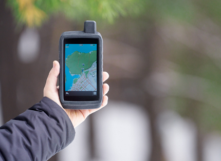
The Montana 700i weighs 410 grams (14.4 ounces) and measures 9.1 x 18.3 x 3.2 centimeters, making it substantial but manageable for both handheld and vehicle-mounted use. The device is MIL-STD-810 certified, meaning it meets military standards for thermal resistance, shock absorption, water protection, and vibration tolerance. This certification ensures the unit can survive temperature extremes, from freezing winter conditions to scorching desert heat, though some users have reported challenges with touchscreen operation in temperatures below negative 10 degrees Celsius without maintaining a constant power connection.
The touchscreen interface operates similarly to modern smartphones, with the ability to arrange, add, and remove icons from the main menu. The processor offers noticeably faster performance compared to older Garmin handheld units, with quicker map rendering and more responsive touch controls. The unit uses both GPS and Galileo satellite systems for positioning accuracy typically within 25 feet, performing on par with other high-end Garmin devices like the GPSMAP 66i series.
The inReach functionality requires an active subscription, with the most basic annual plan starting at approximately 143 dollars and 40 cents. This provides two-way satellite messaging capability using the global Iridium satellite network, allowing users to send texts to any mobile phone number or email address, post to social media, and most importantly, trigger interactive SOS alerts that connect directly with professional rescue coordination centers. The large 5-inch screen makes typing messages significantly easier compared to smaller devices, featuring a QWERTY touchscreen keyboard that’s far more user-friendly than button-based text entry.
One notable advantage is the unit’s 16 gigabytes of internal storage, though approximately 14.3 gigabytes displays under Windows, with 2.42 gigabytes available after preinstalled maps. The device accepts microSD cards for expanded storage capacity. Preloaded maps include TopoActive topographic maps and CityNavigator street maps for the 700i and 750i models, providing comprehensive coverage for both on-road and off-road navigation.
Battery life varies depending on usage, but users report approximately 16 hours in standard GPS mode. The unit includes Expedition Mode, which significantly reduces functionality but can extend battery life to up to two weeks according to Garmin specifications. The Montana 700i can be powered via USB cable or directly through 12-volt vehicle power using the included mounting system.
Best For: Overlanders and solo adventurers who venture into extremely remote areas where safety is non-negotiable. It’s a powerful GPS and a lifeline in one.
Key Features: Global Iridium satellite network, preloaded TopoActive maps, supports geocaching, excellent battery life, both touchscreen and button-operated, barometric altimeter, three-axis compass, wireless connectivity via ANT+, Bluetooth LE, USB and Wi-Fi, BirdsEye satellite imagery compatibility.
Pricing: Approximately 700 dollars for the Montana 700i. The Montana 750i, which includes an 8-megapixel camera, typically retails for slightly more, though many users find their smartphone cameras superior and recommend the 700i as the better value.
2. Garmin Overlander: The Vehicle-Centric Powerhouse
The Lowdown: Designed from the wheels up for vehicle-based expeditions, the Overlander is more than a handheld. Its sleek, dash-mounted unit features a 7-inch display and comes preloaded with global public land maps and dirt trail networks. Its killer app is the integrated public campsite database and scenic route planning.
The Garmin Overlander represents a paradigm shift in off-road navigation, purpose-built for vehicle-based travel with a 7-inch capacitive touchscreen offering 1024 x 600 pixel resolution. Weighing approximately 15.4 ounces (roughly half a kilogram), the unit feels substantial and durable in hand, designed to withstand the rigors of rough expeditions. The display remains clear and legible in both harsh sunlight and low-light conditions, utilizing anti-glare technology that ensures consistent readability.
What truly distinguishes the Overlander is its seamless integration of practical overlanding resources. The unit comes preloaded with iOverlander points of interest and Ultimate Public Campgrounds database, allowing users to locate established, wild, and dispersed campsites without requiring cell signal. This integration eliminates the need to juggle multiple apps and resources while on the trail, providing instant access to thousands of campsites and points of interest across North and South America.
The device includes an impressive 64 gigabytes of internal storage, providing ample space for additional maps, USGS quad sheets, and custom waypoints. Users can leverage the Garmin Explore app to download supplemental maps and wirelessly sync data between devices when Wi-Fi connection is available. The unit also integrates with Tracks4Africa for African continent navigation, expanding its utility for international overlanding adventures.
Navigation capabilities include two distinct modes: Drive and Explore. Drive mode provides traditional turn-by-turn directions with a bird’s-eye view of the road ahead, perfect for street navigation. Explore mode offers a 2D top-down topographic view highlighting roads, side-tracks, and elevation contour lines. This dual-mode approach allows users to seamlessly transition between highway travel and backcountry exploration without switching devices.
The Overlander excels in vehicle-specific routing customization. Users can input their vehicle’s height, weight, and length, and the system provides customized routing with alerts for upcoming bridge heights, weight limits, sharp curves, and steep grades. This functionality proves invaluable for larger overlanding vehicles, camper vans, or vehicles towing trailers, helping avoid situations where road restrictions could create dangerous or impossible passage.
Built-in navigational tools include a digital compass, barometric altimeter, and integrated pitch and roll gauges (with optional accessory calibration). The pitch and roll display provides real-time visual confirmation of terrain severity, showing exact angles when navigating side slopes or steep declines. Multi-GNSS support encompasses GPS, GLONASS, and Galileo satellite systems, ensuring reliable positioning even in challenging environments with limited sky visibility.
The unit comes with a powered magnetic mount system that includes both suction cup and RAM-compatible adapter options, allowing flexible mounting solutions. The magnetic connection enables the device to automatically power up and charge without requiring physical cable connections each time, though this also means users should avoid leaving the unit powered on when exiting the vehicle to prevent battery drain.
Battery performance delivers approximately eight hours in normal operating conditions, with power-saving modes extending operation to potentially 60 hours. The unit can also be continuously powered via 12-volt vehicle connection for unlimited use during travel.
While the Overlander offers impressive capabilities, some users note limitations. Map detail levels don’t quite match specialized apps like Gaia GPS, particularly for extremely remote or less-traveled areas. The device can be somewhat stubborn during startup, occasionally requiring multiple attempts to power on properly. Some users report that on-road navigation, while functional, lags behind mainstream navigation systems like Google Maps in terms of routing intelligence and real-time traffic awareness.
The unit does not include integrated inReach satellite communication—users must pair it separately with a Garmin inReach device for satellite messaging and SOS capabilities. However, this pairing process is relatively straightforward, and many overlanders appreciate the flexibility of choosing whether to carry satellite communication capabilities.
Best For: Overlanders who spend nights in their rigs and prioritize discovering campsites, managing multi-day routes, and using a clean, vehicle-integrated interface.
Key Features: 7-inch capacitive touchscreen, preloaded iOverlander points of interest, pitch and roll gauges (with optional accessory), built-in dash cam mode compatibility, supports pairing with Garmin inReach satellite communicators (sold separately), integration with up to four BC 35 backup cameras, Garmin PowerSwitch digital switch box compatibility for controlling 12-volt accessories, 64GB storage capacity.
Pricing: Typically retails for approximately 699 dollars and 99 cents, representing a significant investment but offering comprehensive vehicle-centric navigation features.
3. Trail Tech Voyager Pro: The Data Dashboard
The Lowdown: This unit is a favorite among moto and UTV/ATV enthusiasts but is incredibly capable for smaller 4x4s. The Voyager Pro is less about global maps and more about being an integrated vehicle dashboard and trail mapper. It connects to your engine’s sensors to display real-time diagnostics (temperature, RPM, voltage) alongside your navigation.
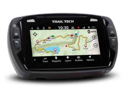
The Trail Tech Voyager Pro represents a fundamentally different approach to off-road GPS technology, combining navigation capabilities with comprehensive vehicle monitoring in a single, shock-resistant package. At 5.6 x 3.5 inches, the unit fits comfortably on dirt bike dashboards while remaining large enough for adventure bikes, ATVs, UTVs, and side-by-sides.
The standout feature is the Voyager Pro’s full vehicle integration through standard Trail Tech sensors. The system connects to engine temperature sensors, tachometers, and electrical systems to provide vital ride data including coolant temperature, engine RPM, battery voltage, speed, distance traveled, and more. This integration transforms the unit from a simple navigation device into a complete digital instrument cluster, eliminating the need for separate gauges and creating a cleaner, more streamlined dashboard.
The 4.25-inch color touchscreen proves remarkably bright and visible even in direct sunlight, with touch response that works reliably with gloves. Map rendering occurs quickly without excessive lag or skipping, and the interface responds rapidly when changing between screens. The device offers multiple display screens, including a customizable user screen where riders can select up to six gauge readouts from an extensive list of options, allowing personalization based on specific needs and preferences.
Navigation functionality centers on recording and following GPX trails. Users can import and export GPX files with remarkable simplicity, loading new routes, trails, and waypoints, or downloading recorded adventures for sharing with others. The unit comes preloaded with North American maps derived from Open Street Maps, with topographical lines and hill shading. Additional map regions can be downloaded for free from the Trail Tech website. While forest service roads and BLM routes appear with varying consistency, the system excels at recording detailed, high-resolution trail maps in areas without existing coverage.
One particularly innovative feature is Buddy Tracking, which uses localized radio signals independent of cell reception to display the real-time location of up to 20 riders in a single group on the map screen. This capability integrates seamlessly with Polaris RideCommand Group Ride systems, allowing Trail Tech users to join Polaris ride groups. The emergency beacon function enables riders to summon help from their group when needed, providing an additional safety layer without requiring satellite communication subscriptions.
The Voyager Pro includes Bluetooth connectivity for intercom, phone dialing, messaging, and media controls. Users can play music from smartphones or microSD cards through Bluetooth headsets, speakers, or intercoms, with the ability to connect two phones and two headsets simultaneously. The media screen provides full control over volume, song playback, dialing, call history, and messaging features, compatible with popular systems like Lexin, Cardo, and Sena.
Additional screens include a stopwatch for lap timing, a satellite screen displaying GPS satellites in range with signal strength graphs, and extensive settings menus for customization. The unit requires 12-volt DC power, making it suitable only for vehicles equipped with batteries.
While the Voyager Pro offers exceptional capabilities for powersports applications, it does have limitations. The system does not provide turn-by-turn navigation like mainstream GPS units, focusing instead on track following and recording. Trail Tech has explored options for implementing turn-by-turn navigation through Bluetooth connectivity with smartphones, but this remains under development. The base maps, while adequate, lack the comprehensive detail of larger GPS manufacturers, particularly for urban areas and secondary roads.
Installation requires careful attention to wiring and routing, with included harnesses providing robust connections for all sensors. The included L-shaped handlebar mount works well but may obscure original equipment manufacturer gauge clusters, potentially blocking access to indicator lights and turn signals. Trail Tech offers a Voyager Pro Indicator Dashboard as an additional purchase to address this limitation, though many users prefer RAM mount systems for maximum flexibility.
The quick-removal docking station allows riders to easily remove the unit when parking, with the dock utilizing the AMPS hole pattern for compatibility with various mounting systems. Users can purchase additional docks to move the Voyager Pro head unit between multiple vehicles, maximizing the value of the investment.
Best For: Rock crawlers, trail riders, and anyone who wants vital engine data and navigation in one shock, vibration, and waterproof unit. Particularly well-suited for motorcycles, ATVs, UTVs, side-by-sides, and snowmobiles where integrated vehicle monitoring adds significant value.
Key Features: 4.25-inch glove-friendly touchscreen, customizable digital gauge clusters, creates and follows high-resolution trail maps, Buddy Tracking for up to 20 riders, Bluetooth audio and communication integration, vehicle sensor integration for temperature, RPM, voltage, and speed data, microSD card compatibility, IPX7 waterproof rating, extremely durable construction designed specifically for powersports applications.
Pricing: Kit pricing varies by vehicle application, typically ranging from 500 to 600 dollars depending on included sensors and mounting hardware. Different kits available for motorcycles, ATVs, UTVs, and snowmobiles with application-specific components.
4. Lowrance Baja 540C: The Desert Racer’s Choice
The Lowdown: Born from the brutal demands of the Baja 1000, Lowrance units are legendary for their toughness and clarity. The Baja series offers powerful, detailed cartography with public and private land boundaries clearly marked. Their touchscreen is highly responsive, even when wet, and they support detailed marine charts—perfect for the angler who also off-roads.
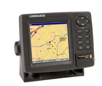
The Lowrance Baja series has earned legendary status in the off-road racing community, with units visible in Ultra4 and desert race vehicles competing at events like King of the Hammers and the Baja 1000. This racing pedigree translates directly into recreational trail use, offering exceptional durability and performance in the harshest conditions imaginable.
Originally designed for marine applications in corrosive saltwater environments, Lowrance units feature dust-proof and waterproof housing that easily withstands off-road abuse. The 5-inch screen models have housings measuring approximately 7 inches wide, 6 inches tall, and 3 inches deep, creating a substantial unit that requires thoughtful installation planning rather than casual portable use.
The hallmark of Lowrance GPS units is their ultra-bright, high-contrast displays that remain exceptionally clear in direct sunlight. Current touchscreen models feature responsive interfaces that work even when wet, with pinch-to-zoom functionality and intuitive menu navigation once users familiarize themselves with the Lowrance ecosystem. Some models include physical buttons on the right side for easier operation while driving, allowing users to navigate through menus without touching the screen.
One significant advantage is the 10Hz update frequency, providing ten position updates per second compared to the 1Hz frequency of most competitors. This high update rate proves particularly valuable for high-speed desert running, ensuring the position indicator moves smoothly across the map rather than jumping between points. For racers and fast-paced trail runners, this responsiveness makes a substantial difference in navigation confidence.
The base mapping provided with Lowrance units shows major roads and highways but lacks detail on residential streets and many forest roads. However, the real power lies in the unit’s ability to display custom satellite imagery maps on SD cards. Offline satellite GPS maps from third-party sources like Rugged Routes provide exceptional detail with up to 0.5-meter per pixel resolution, showcasing aerial imagery, highways, residential streets, BLM and USFS routes, 4×4 trails, enhanced points of interest with photos and informative text, recreation areas, campgrounds, and more.
Public and private land boundaries appear clearly delineated through shading, helping users avoid trespassing situations. This land ownership mapping proves invaluable in Western terrains where public and private lands intermingle in complex patterns. Small details like water tanks appearing in seemingly remote locations demonstrate the thoroughness of available mapping data.
Lowrance units utilize a page-based interface rather than a single consolidated screen, allowing users to rotate through different views including maps, trip calculators, trail listings, and waypoint directories. Each page offers its own menu system, with a main menu accessible via the menu button for universal settings. The learning curve requires investment, but knowledge transfers between most Lowrance models, creating consistency for users who upgrade or use multiple units.
Current models include Elite and HDS series units. The Elite series offers more affordable pricing, while the HDS series features additional physical buttons for easier operation during movement and video input capability that the Elite lacks. The Baja designation indicates inclusion of the Point-1 Baja GPS puck antenna with integrated compass, providing enhanced positioning accuracy for vehicles where the GPS unit is mounted in locations with obstructed sky visibility.
The newer Trophy-5M Baja and HDS-7 LIVE BAJA models represent streamlined versions of the original Baja 540C, offering touchscreen functionality, wireless connectivity, and improved processing power. Optional Topo Insight Pro mapping provides land-based cartography designed specifically for off-road enthusiasts and racers, ensuring comprehensive trail coverage.
However, Lowrance units do not offer turn-by-turn navigation or automatic routing. Users must create routes manually using programs like Google Earth, drawing from coordinates in guidebooks, or downloading existing files from crowd-sourced libraries like AllTrails. Lowrance offers Topo Insight and Insight Planner mapping software to assist with map creation and waypoint management, but the workflow requires more hands-on effort compared to mainstream GPS systems.
The lack of portable mounting solutions means Lowrance units work best as permanent or semi-permanent vehicle installations. The three connection cables—antenna, power, and optional accessories—create installation complexity requiring thoughtful cable routing and management.
Best For: High-speed desert runners, those who frequent wide-open Western terrains, and anyone needing crystal-clear land ownership mapping to avoid trespassing. Particularly valuable for users who enjoy creating custom maps and routes, or who need marine navigation capabilities alongside off-road functionality.
Key Features: Ultra-bright 5-inch display (larger sizes available up to 12 inches), preloaded C-MAP TOPO+ maps, built-in SiriusXM satellite weather and radio compatibility (with subscription), legendary rugged housing, 10Hz position update frequency, support for custom satellite imagery maps with exceptional resolution, clear public and private land boundary delineation, video input capability on HDS models, optional Point-1 Baja GPS antenna with integrated compass.
Pricing: Current Trophy-5M Baja models typically retail around 450 to 500 dollars. Larger HDS series units range from 700 to over 1,000 dollars depending on screen size and features. The original Baja 540C has been discontinued but established the reputation that current models build upon.
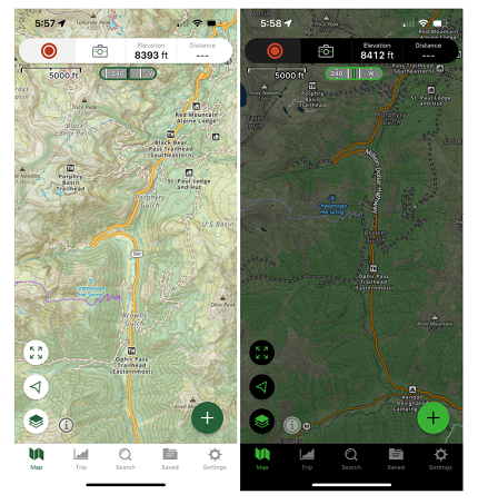
5. Smartphone with Gaia GPS App (The Savvy Alternative)
The Lowdown: Don’t underestimate a smartphone running a pro app like Gaia GPS or OnX Offroad, paired with a rugged external battery and a quality mount. You get access to incredible map layers (USGS, MVUM, private land), real-time tracking, and easy route sharing for a fraction of the hardware cost.
Modern smartphone navigation apps have evolved dramatically, offering capabilities that rival and in some cases exceed dedicated GPS units—provided users understand the limitations and plan accordingly. Gaia GPS and OnX Offroad represent the two dominant players in the off-road navigation app market, each offering distinct advantages for different user types.
Gaia GPS has established itself as the most versatile mapping platform for overlanders, outdoor enthusiasts, and anyone requiring customizable navigation solutions. Founded in 2008 in Berkeley, California, the app initially attracted hikers and backpackers but quickly gained traction among off-roaders who recognized the value of its extensive basemap selection.
The defining strength of Gaia GPS is customization. Users can layer multiple map types simultaneously, including topographic maps, satellite imagery, USFS and BLM public land maps, private land ownership boundaries, and even cellular coverage prediction maps showing estimated coverage for AT&T, Verizon, and T-Mobile networks. This coverage mapping proves invaluable during trip planning, helping users determine realistic expectations for communication capabilities in remote areas.
Gaia GPS excels at pre-trip route planning through its web-based interface. Users can plan detailed routes, mark waypoints with notes and photos, and organize everything into hierarchical folder structures—for example, creating folders for specific regions, then subfolders for individual trips within those regions. When users open the mobile app with Wi-Fi or cellular connection, all data automatically syncs, ensuring routes and waypoints are ready before venturing into the backcountry.
The offline map functionality offers exceptional flexibility. Users select specific map layers and geographic regions for download, ensuring access to high-detail topographic, satellite, and road maps without cell service. This granular control allows users to optimize storage usage by downloading only needed map data at appropriate resolution levels.
Waypoint management in Gaia GPS provides extensive customization options. Users can attach detailed notes, select from numerous icons, and include photos with waypoints, making it easy to document camping spots, water sources, trail obstacles, or points of interest. The app seamlessly integrates with Trails Offroad, a curated database of vehicle trails with video documentation, GPX tracks, waypoint details, difficulty ratings, trail condition reports, and user reviews. This partnership (requiring a separate 25-dollar annual subscription) provides high-quality trail information without the need for Gaia GPS to maintain its own trail curation.
Premium Gaia GPS membership costs approximately 59 dollars and 99 cents annually, providing access to all 50 states plus advanced features. This pricing undercuts OnX significantly while offering arguably greater functionality for map customization and route planning. The app includes Apple CarPlay functionality, allowing seamless integration with vehicle infotainment systems. However, the user interface has remained largely unchanged since the app’s early days, appearing dated compared to modern app design standards, and the extensive customization options create a steeper learning curve for new users.
OnX Offroad emerged from OnX Hunt in 2019, bringing the company’s mapping expertise from the hunting world into off-road navigation. The app’s primary strength lies in its extensive, curated database of off-road trails with difficulty ratings, user reviews, and comprehensive trail descriptions. OnX features thousands of pre-mapped trails designed to help users discover and navigate established routes without extensive research.
The app prioritizes simplicity and trail discovery over deep customization. The clean interface proves more intuitive for beginners, with streamlined workflows that emphasize finding trails and hitting the road quickly. Monthly updates add curated content and trail information, though the frequency of trail condition updates varies, and users have occasionally reported outdated information on closed trails.
OnX Offroad supports offline map downloads, though the process is more rigid than Gaia GPS, with less flexibility in customizing detail levels for offline use. The app includes waypoint marking capabilities but with less extensive customization compared to Gaia GPS—photo attachments are supported but not as seamlessly integrated.
One significant limitation is the absence of route planning functionality. OnX focuses on following pre-existing trails rather than allowing users to create custom routes from scratch. The app also lacks a direct link to mainstream navigation apps like Google Maps or Apple Maps for getting turn-by-turn directions to trailheads, requiring users to manually copy coordinates and paste them into separate navigation apps.
Pricing for OnX Offroad runs approximately 99 dollars and 99 cents annually for all 50 states, or 34 dollars and 99 cents per year for single-state access. This higher price point compared to Gaia GPS makes sense primarily for users who heavily utilize the pre-curated trail database and prefer not to invest time in route planning.
Both apps support standard GPS functionality available on smartphones, though dedicated GPS units typically offer superior antenna performance and more reliable positioning in challenging environments like deep canyons or dense forest canopy. Smartphone GPS chips have improved dramatically in recent years, but they still cannot match the reception quality of high-end dedicated units.
Best For: The budget-conscious or casual off-roader who already sticks to areas with some cell coverage, or who diligently pre-downloads maps. Also ideal for users who enjoy the flexibility of using their existing smartphone rather than carrying additional devices.
Crucial Caveat: This approach relies on your phone’s less-durable hardware and GPS chip. Smartphones are vulnerable to temperature extremes, impacts, water exposure, and battery drain. Screen visibility in direct sunlight often proves inferior to dedicated units. Always carry paper maps and a compass as backup, and consider investing in a rugged phone case, quality mounting system, and high-capacity external battery pack.
Key Features: Low cost of entry, unparalleled map layer selection (Gaia GPS), extensive trail database with difficulty ratings (OnX Offroad), easy updates, seamless desktop planning, offline map capability, waypoint management, track recording, route sharing, integration with other outdoor apps and services.
Pricing: Gaia GPS Premium membership approximately 59 dollars and 99 cents annually (often discounted to 29 dollars through Overland Bound member programs). OnX Offroad approximately 99 dollars and 99 cents annually for all states or 34 dollars and 99 cents for single-state access. Both apps offer free trials with limited functionality to test before purchasing.
The Buying Checklist: What to Look For
Investing in the right GPS unit requires careful consideration of multiple factors. Use this comprehensive checklist to evaluate options based on your specific off-road needs and adventure style.
Ruggedness: The device should carry an IPX7 waterproof rating at minimum, ensuring it can withstand immersion in up to one meter of water for 30 minutes. Look for dustproof construction and shock resistance specifications. Military-grade certification (MIL-STD-810) indicates testing for thermal extremes, vibration tolerance, and impact resistance. Consider whether you need a unit that operates in freezing temperatures if you plan winter adventures.
Preloaded Maps: Quality preloaded mapping separates exceptional units from adequate ones. Topographic maps with contour lines help visualize terrain difficulty and elevation changes. Public land boundary data for BLM, USFS, and state lands prevents trespassing issues and helps identify legal camping areas. Look for units that include 4×4 trails, forest roads, and recreational vehicle routes. Global coverage matters for international travel, while North America-focused mapping may suffice for regional adventurers.
Screen Readability: Screen size matters, but brightness and anti-glare treatment matter more. A 5-inch screen with exceptional brightness and contrast outperforms a 7-inch screen that washes out in direct sunlight. Test units outdoors in bright conditions if possible. Consider whether you need glove-friendly touchscreen operation or prefer physical buttons. Higher resolution displays show more map detail without zooming, reducing the need for constant map manipulation while driving.
Power Options: Look for units offering both long internal battery life and 12-volt vehicle power capability. Internal batteries should provide at least 8 to 16 hours of standard operation, with power-saving modes extending this significantly. Vehicle power connection allows unlimited operation during travel and prevents battery drain concerns. USB charging compatibility provides flexibility for recharging from portable battery packs. Quick-disconnect power connections simplify removal when parking in public areas.
Community and Updates: The ability to import and export GPX files ensures compatibility with online route libraries, desktop planning software, and sharing with other users. Check whether the manufacturer provides regular map updates and whether these updates require additional purchases or are included with purchase. Active user communities sharing routes, waypoints, and trail condition reports add tremendous value. Social media groups, forums, and dedicated websites often provide crowdsourced information that complements manufacturer-provided mapping.
Satellite Communication: For adventures in truly remote areas beyond cell coverage, consider units with built-in satellite technology like Garmin’s inReach integration, or plan to pair your GPS with a separate satellite messenger. Subscription costs for satellite services typically range from 11 to 15 dollars monthly for basic plans, escalating for unlimited messaging or advanced features. Evaluate whether two-way messaging matters or whether SOS-only capability suffices for your safety requirements.
Vehicle Integration: Consider whether you need vehicle sensor integration for displaying engine temperature, RPM, voltage, and other diagnostic data. Units like the Trail Tech Voyager Pro excel in this area, consolidating multiple instruments into one device. Mounting options should match your vehicle type—suction cups work well for smooth dashboard surfaces, while RAM mounts offer robust solutions for rough terrain. Magnetic mounting systems provide quick removal capabilities valuable in areas where theft concerns exist.
Storage Capacity: Internal storage should accommodate base maps plus room for additional custom maps, waypoints, routes, and tracks. Look for 8 to 16 gigabytes minimum, with microSD card expansion capability for virtually unlimited storage. Consider your archiving needs—users who record extensive tracks and maintain large waypoint libraries require more storage than those who focus on following pre-planned routes.
User Interface: The navigation interface should feel intuitive for your skill level and preferences. Touchscreen operation mimics smartphone interaction, appealing to users comfortable with mobile devices. Button-based operation works better with heavy gloves and provides tactile feedback without looking at the screen. Page-based interfaces (like Lowrance) differ fundamentally from app-style interfaces (like Garmin), requiring different mental models for navigation.
Additional Features: Evaluate secondary capabilities that might enhance your adventures. Geocaching support adds entertainment value for family trips. Pitch and roll gauges help assess vehicle angles on technical terrain. Altimeters and barometers provide elevation and weather prediction data. Bluetooth connectivity enables hands-free phone calls and music playback through vehicle audio systems. Camera integration allows documenting waypoints with georeferenced photos. Buddy tracking systems help groups stay connected without cell service.
The Verdict
There’s no single “best” unit—only the best one for your type of adventure. Prioritize safety and communication? The Garmin Montana 700i is unmatched, combining robust navigation with life-saving satellite SOS capabilities in a single, military-grade package. Living out of your vehicle for weeks at a time? The Garmin Overlander transforms into your mobile command center, with its 7-inch screen, integrated campsite databases, and vehicle-specific routing making extended expeditions significantly more manageable.
Need comprehensive engine data alongside directions? The Trail Tech Voyager Pro integrates navigation with vital vehicle diagnostics, creating an all-in-one dashboard solution perfect for motorcycles, ATVs, and UTVs. Blazing across open desert landscapes at high speeds? The Lowrance Baja series excels with its ultra-bright display, 10Hz update frequency, and crystal-clear land ownership mapping derived from decades of marine electronics expertise.
On a budget but still want powerful navigation capabilities? Don’t overlook modern smartphone apps like Gaia GPS or OnX Offroad. When paired with proper preparation—pre-downloaded offline maps, a rugged case, quality mounting system, and backup power—smartphones deliver remarkable functionality for a fraction of dedicated unit costs. However, always maintain redundancy: carry paper maps, a compass, and backup navigation methods.
Investing in a proper off-road GPS transforms the experience. It turns anxiety about getting lost into the confidence to explore further, venture deeper, and discover places you would never attempt with casual navigation tools. You spend less time worrying about the route and more time enjoying breathtaking views from far, far off the beaten path. The right GPS unit becomes not just a tool but a trusted companion that expands your adventure horizons while providing peace of mind that you can always find your way home.
Consider starting with a mid-range unit or smartphone app to understand your preferences and usage patterns. As your adventures become more ambitious and remote, you can upgrade to more sophisticated units with additional capabilities. The learning curve for any GPS system requires patience—spend time at home mastering the interface, practicing route planning, and understanding features before depending on the unit in challenging backcountry situations.
Join online communities dedicated to your chosen GPS platform. These groups provide invaluable tips, tricks, custom maps, and shared routes that accelerate your learning and enhance your adventures. Many experienced users gladly share waypoints for incredible camping spots, scenic overlooks, and challenging trails, building a collective knowledge base that benefits all members.
Remember that technology serves as a tool, not a replacement for skills and judgment. Understanding topographic map reading, recognizing terrain features, estimating distances, and maintaining situational awareness remain crucial abilities regardless of GPS sophistication. Use technology to enhance these fundamental outdoor skills rather than replacing them.
Now, gear up, plot your course, and go discover that trail less traveled. The backcountry awaits, and with the right GPS unit, you’re equipped to explore it safely and confidently.
Disclaimer
Always recreate responsibly on designated trails. Verify land access and regulations before departure, respecting private property boundaries and seasonal closures. Practice Leave No Trace principles by staying on established paths, packing out all trash, minimizing campfire impacts, and respecting wildlife. Remember that GPS technology aids navigation but cannot replace preparation, common sense, and respect for the natural environment. Carry appropriate safety equipment, inform others of your plans, check weather forecasts, and understand your vehicle’s capabilities and limitations. The wilderness demands respect—explore responsibly to ensure these trails remain accessible for future adventurers.
*) If you enjoyed this article, here are some related posts you might find interesting.